Surrey

Surrey

Faane
KarteBirminghamCoventryMetropolitan Borough of SolihullWolverhamptonMetropolitan Borough of WalsallSandwellMetropolitan Borough of DudleyKirkleesCity of WakefieldCity of LeedsCity of BradfordCalderdaleNorth TynesideSouth TynesideCity of SunderlandMetropolitan Borough of GatesheadNewcastle upon TyneMetropolitan Borough of WirralLiverpoolMetropolitan Borough of SeftonKnowsleyMetropolitan Borough of St HelensMetropolitan Borough of BarnsleySheffieldMetropolitan Borough of RotherhamMetropolitan Borough of DoncasterMetropolitan Borough of WiganCity of SalfordTraffordManchesterMetropolitan Borough of StockportTamesideMetropolitan Borough of OldhamMetropolitan Borough of RochdaleMetropolitan Borough of BuryMetropolitan Borough of BoltonFrankreichIrlandIsle of ManSchottlandNordirlandWalesGreater LondonSurreyBuckinghamshireKentEssexHertfordshireSuffolkNorfolkLincolnshireRutlandCambridgeshireEast SussexWest SussexIsle of WightHampshireDorsetDevon (England)CornwallBristolSomersetWiltshireGloucestershireLeicestershireNorthamptonshireOxfordshireHerefordshireWarwickshireWorcestershireWest Midlands (Metropolitan County)ShropshireStaffordshireNottinghamshireDerbyshireCheshireMerseysideGreater ManchesterSouth YorkshireEast Riding of YorkshireWest YorkshireLancashireNorth YorkshireCumbriaNorthumberlandTyne and WearCounty Durham (Unitary Authority)DarlingtonBorough of Stockton-on-TeesMiddlesbroughRedcar and ClevelandHartlepoolBlackburn with DarwenCity of YorkKingston upon HullNorth East LincolnshireBorough of HaltonBorough of WarringtonCheshire West and ChesterStoke-on-TrentTelford and WrekinDerby (Derbyshire)NottinghamLeicesterCity of PeterboroughBorough of SwindonSouthend-on-SeaBorough of MedwayThurrockBedfordshireBorough of Milton KeynesLutonCentral BedfordshireNorth SomersetSouth GloucestershireBath and North East SomersetPlymouthTorbayScilly-InselnPooleBournemouthSouthamptonPortsmouthBrighton and HoveReadingWest BerkshireWokinghamBracknell ForestSloughWindsor and Maidenhead
Karte

Geographischi Laag in Ängland
Geografii
Status Verwaltigsgroofschaft
Region South East England
Flechi 1.663 km²
Verwaltigssitz Kingston
ISO 3166-2 GB-SRY
Demografii
Bevölkerig
Dichti
1.132.390 (2011)
678 / km²
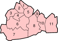
Distrikt
  1. Spelthorne
  2. Runnymede
  3. Surrey Heath
  4. Woking
  5. Elmbridge
  6. Guildford
  7. Waverley
  8. Mole Valley
  9. Epsom and Ewell
  10. Reigate and Banstead
  11. Tandridge

Surrey [ˈsʌɹɪ] isch e Groofschaft (County) im Süde vo Ängland. Si bestoot us de Distrikt Elmbridge, Epsom and Ewell, Guildford, Mole Valley, Reigate and Banstead, Runnymede, Spelthorne, Surrey Heath, Tandridge, Waverley und Woking. D Groofschaft gränzt an Hampshire, Berkshire, Greater London, Kent, East Sussex und West Sussex.

Surrey het öbbe äi Millioon Iiwooner. Die dradizionelli Hauptstadt vo dr Groofschaft isch Guildford gsi, wo au d University of Surrey isch. Geegewärtig befindet sich dr Sitz vo dr Verwaltig z Kingston upon Thames, wo sit 1965 nüme in dr Groofschaft lit; es ghöört zu Greater London. Es git Blään, d Verwaltig uf Woking z verlege.

Wil s eso nooch zu London isch, git s in Surrey e Hufe Pändlergmäinde, d Bevölkerigsdichti isch seer hooch und d Bewooner si im Durchschnitt woolhabender as anderi Bürger vom Veräinigte Köönigriich.

E groosse Däil vo Surrey lit im Grüene Gürtel, und wil dr Boode seer sandig isch und er nume begränzt landwirtschaftlig cha gnutzt wärde, git s e Hufe Fuess- und Ritwääg. Dorum isch Surrey riich an Möögligkäite für ländligi Freizitaktividääte. D Garte- und Parkaalaage in dr Regioon si in s European Garden Heritage Network iibunde.

Surrey isch usserdäm d Häimet von e Hufe Star. Musiker wie dr Phil Collins, Eric Clapton, Bryan Ferry und Ringo Starr lääbe in Surrey. Au Färnsee-Star wie d Liz Hurley häi Landhüüser in dr Groofschaft.


From Wikipedia, the free encyclopedia · View on Wikipedia

Developed by Nelliwinne