Back شنت ميجال Arabic Saint-Michel-Chef-Chef BM Sant-Mikael-Keveger Breton Saint-Michel-Chef-Chef Catalan Сен-Мишель-Шеф-Шеф CE Saint-Michel-Chef-Chef CEB Sant-Mikael-Keveger Welsh Saint-Michel-Chef-Chef German Saint-Michel-Chef-Chef DIQ Saint-Michel-Chef-Chef English
 | |||
| |||
| Alministración | |||
| País | |||
| Organización territorial | Francia metropolitana | ||
| Rexón | |||
| Departamentu | |||
| Tipu d'entidá | comuña de Francia | ||
| Nome oficial | Saint-Michel-Chef-Chef (fr)[1] | ||
| Códigu postal |
44730 | ||
| Xeografía | |||
| Coordenaes | 47°10′51″N 2°08′55″W / 47.1808°N 2.1486°O | ||
 | |||
| Superficie | 25.12 km² | ||
| Altitú | 0 m[2] y 57 m[2] | ||
| Llenda con | La Plaine-sur-Mer, Pornic, Saint-Brevin-les-Pins y Saint-Père-en-Retz | ||
| Demografía | |||
| Población |
5520 hab. (1r xineru 2022) - 2408 homes (2017) - 2585 muyeres (2017) | ||
| Porcentaxe | 0.37% de Loira Atlánticu | ||
| Densidá | 219,75 hab/km² | ||
| Más información | |||
| Estaya horaria |
UTC+01:00 (horariu estándar) UTC+02:00 (horariu de branu) | ||
| stmichelchefchef.fr | |||
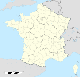
Saint-Michel-Chef-Chef ye una ciudá francesa. Ta asitiada na rexón de Países del Loira, departamentu de Loira Atlánticu. Tien 5520 habitantes (1 xineru 2022)[3][4].
- ↑ «code officiel géographique». Consultáu'l 6 xineru 2019.
- ↑ 2,0 2,1 Tienes d'especificar urlarchivu = y fechaarchivu = al usar {{cita web}}.«répertoire géographique des communes». Institut national de l'information géographique et forestière (2015).
- ↑ Afirmao en: Populations de référence 2022. Editorial: Institut national de la statistique et des études économiques. Llingua de la obra o nome: francés. Data d'espublización: 19 avientu 2024.
- ↑ censu de población

