Back خويسه ميرين Arabic Gooise Meren Catalan Gooise Meren CEB Gooise Meren German Gooise Meren English Gooise Meren Esperanto Gooise Meren Spanish خویسه میرن Persian Gooise Meren French Goaiske Marren Frisian
| Gooise Meren | |||
|---|---|---|---|
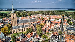
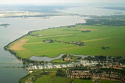
Bussum across from city hall Aerial view of the historic city of Naarden Aerial view of Muiden and Muiden Castle Dorpsstraat in Muiderberg | |||
| |||
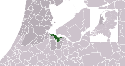
 Location in North Holland | |||
| Koordinat: 52°17′00″N 5°10′00″E / 52.2833°N 5.1667°E | |||
| Country | Netherlands | ||
| Province | North Holland | ||
| Region | Amsterdam metropolitan area | ||
| Established | 1 January 2016[1] | ||
| Pamréntahan | |||
| • Lembaga | Municipal council | ||
| • Mayor | Han ter Heegde (VVD) | ||
| Jimbar | |||
| • Total | 75,22 km2 (2,904 sq mi) | ||
| • Darat | 41,59 km2 (1,606 sq mi) | ||
| • Air | 33,63 km2 (12,98 sq mi) | ||
| Populasi (Januari 2021)[4] | |||
| • Total | 58.524 | ||
| • Kepadatan | 1.407/km2 (3,640/sq mi) | ||
| Wewidangan galah | UTC+1 (CET) | ||
| • Musim panas (DST) | UTC+2 (CEST) | ||
| Postcode | 1398–1406, 1410–1414 | ||
| Area code | 0294, 035 | ||
| Situs web | gooisemeren | ||

Gooise Meren (kaucapang [ˈɣoːisə ˈmeːrə(n)]) inggih punika kotamadya sané wenten ring propinsi Holland Kalér, Belanda.
- ↑ "Gemeentelijke indeling op 1 januari 2016" [Municipal divisions on 1 January 2016]. cbs.nl (ring Dutch). CBS. Kaaksés 9 November 2018.CS1 maint: unrecognized language (link)
- ↑ "Burgemeester Han ter Heegde" [Mayor Han ter Heegde] (ring Dutch). Gemeente Gooise Meren. Kaarsipin saking versi asli tanggal 10 November 2018. Kaaksés 9 November 2018.CS1 maint: unrecognized language (link)
- ↑ "Kerncijfers wijken en buurten 2020" [Key figures for neighbourhoods 2020]. StatLine (ring Belanda). CBS. 24 Juli 2020. Kaaksés 19 Séptémber 2020.
- ↑ "Bevolkingsontwikkeling; regio per maand" [Population growth; regions per month]. CBS Statline (ring Belanda). CBS. 1 Januari 2021. Kaaksés 2 Januari 2022.


