Back Sarangani, Davao Occidental BCL Sarangani, Davao Occidental CEB Sarangani (Davao Occidental) German Sarangani, Davao Occidental English Sarangani Spanish Sarangani (ville) French Sarangani, Davao Occidental ID Sarangani, Davao Occidental ILO Sarangani (Davao del Sur) Italian სარანგანი (დასავლეთი დავაო) Georgian
Sarangani | |
|---|---|
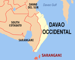
 Mapa de Davao Occidental con Sarangani resaltado | |
 | |
| Coordinates: 5°24'43"N, 125°25'19"E | |
| Nación | Filipinas |
| Región | Región de Davao (Región XI) |
| Provincia | Davao Occidental |
| Número de barangay | 12 |
| Gobierno | |
| • Type | Sangguniang Bayan |
| • Electorado | 16 294 votantes (9 Mayo 2022) |
| Area | |
• Total | 97,72 kilómetro cuadrado km2 (Formatting error: invalid input when rounding sq mi) |
| Elevation | 25 metro m (Bad rounding hereFormatting error: invalid input when rounding ft) |
| Population (1 Mayo 2020) | |
• Total | 22 515 |
| • Hogares | 5718 |
| Economía | |
| • Clase de ingresos | es un aca cuatro clase de municipalidad |
| • Incidencia de la pobreza | 41,99 |
| • Ingresos | ₱ 142,8 million (2022) |
| • Activos | ₱ 265,4 million (2022) |
| • Pasivos | ₱ 25,45 million (2022) |
| • Gastos | ₱ 119,2 million (2022) |
| Time zone | UTC+8 (PST) |
| Código postal | 8015 |
| PSGC | |
| Código telefonico | 82 |
| Clima | clima ecuatorial |
| Lenguaje nativo | davaeño Cebuano Sarangani Sangihe Tagalog |
| Website | http://www.saranganidavsur.gov.ph/ |
Sarangani es un aca cuatro clase de municipalidad na provincia de Davao Occidental, [[Filipinas]]. Tiene este zona de 97.72 kilómetro cuadrado kilometro cuadrado. Comporme del 1 Mayo 2020 censo este tiene papulidad de 22,515 personas y 5,718 hogares. El designada codigo postal 8015 y PSGC 1108605000.
- ↑
"Province:". PSGC Interactive. Quezon City, Philippines: Philippine Statistics Authority. Retrieved Diciembre 17, 2016.
{{cite web}}: Check date values in:|accessdate=(help) - ↑ "PSA Releases the 2021 City and Municipal Level Poverty Estimates". Autoridad de Estadística de Filipinas. 2 Abril 2024. Retrieved 28 Abril 2024.