Back بلدية دوروتيا ARZ Даратэа (камуна) Byelorussian Дурутеа (община) Bulgarian Dorotea kommun Danish Dorotea (Gemeinde) German Dorotea Municipality English Dorotea (Suecia) Spanish Dorotea vald Estonian Dorotea udalerria Basque بخش دوروتیا Persian
| Dorotea Kommun | ||
| Dorotea | ||
| Munisipyo | ||
|
||
| Nasod | ||
|---|---|---|
| Lalawigan | Västerbottens län | |
| Gitas-on | 366 m (1,201 ft) | |
| Tiganos | 64°34′47″N 15°48′22″E / 64.57981°N 15.80614°E | |
| Capital | Dorotea | |
| Area | 2,802.00 km2 (1,082 sq mi) | |
| Population | 2,874 (2014-04-30) [1] | |
| Density | 1 / km2 (3 / sq mi) | |
| Timezone | CET (UTC+1) | |
| - summer (DST) | CEST (UTC+2) | |
| GeoNames | 2717400 | |
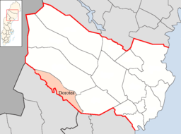
Munisipyo ang Dorotea Kommun sa Sweden.[1] Nahimutang ni sa lalawigan sa Västerbottens län, sa sentro nga bahin sa nasod, 600 km sa amihanan sa Estokolmo ang ulohan sa nasod. Adunay 2,874 ka molupyo.[1] Naglangkob kin og 2,802 ka kilometro kwadrado. Dorotea Kommun mopakigbahin sa usa ka utlanan sa Vilhelmina Kommun, Åsele Kommun, Sollefteå Kommun, ug Strömsunds Kommun.
Ang yuta sa Dorotea Kommun medyo bungtoron.[saysay 1]
Mga lungsod sa Dorotea Kommun:
Sa mosunod nga mga natural nga mga bahin makita sa Dorotea Kommun:
- Gruoneke (tumoy sa bukid)
- Jenjenjetjem (tumoy sa bukid)
- Klinkhöjden (tumoy sa bukid)
- Klöverfjället (tumoy sa bukid)
- Kronakken (tumoy sa bukid)
- Mångmanberget (tumoy sa bukid)
- Njåktjala (tumoy sa bukid)
- Svalatjakken (tumoy sa bukid)
- Tjärrepielke (tumoy sa bukid)
- Vuormovardo (tumoy sa bukid)
Ang klima boreal.[3] Ang kasarangang giiniton −2 °C. Ang kinainitan nga bulan Hulyo, sa 14 °C, ug ang kinabugnawan Enero, sa −14 °C.[4]
- ↑ 1.0 1.1 1.2 Cite error: Invalid
<ref>tag; no text was provided for refs namedgn2717400 - ↑ Cite error: Invalid
<ref>tag; no text was provided for refs namedvp - ↑ Cite error: Invalid
<ref>tag; no text was provided for refs namedkoppen - ↑ Cite error: Invalid
<ref>tag; no text was provided for refs namednasa
Cite error: <ref> tags exist for a group named "saysay", but no corresponding <references group="saysay"/> tag was found


