Back فری پس، فلوریدا AZB Ferry Pass Catalan Ферри-Пасс (Флорида) CE Ferry Pass CEB Ferry Pass, Florida English Ferry Pass Spanish Ferry Pass (Florida) Basque فری پس، فلوریدا Persian Ferry Pass French فري پس (فلؤريدا) GLK
| Ferry Pass | |
|---|---|
|
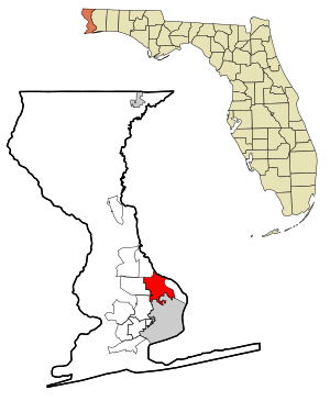
Lage in County und Bundesstaat
| |
| Basisdaten | |
| Staat: | Vereinigte Staaten |
| Bundesstaat: | Florida |
| County: | Escambia County |
| Koordinaten: | 30° 31′ N, 87° 12′ W |
| Zeitzone: | Central (UTC−6/−5) |
| Einwohner: – Metropolregion: |
29.921 (Stand: 2020) 509.905 (Stand: 2020) |
| Haushalte: | 13.228 (Stand: 2020) |
| Fläche: | 36,5 km² (ca. 14 mi²) davon 36,5 km² (ca. 14 mi²) Land |
| Bevölkerungsdichte: | 820 Einwohner je km² |
| Höhe: | 40 m |
| FIPS: | 12-22275 |
| GNIS-ID: | 0282438 |
Ferry Pass ist ein census-designated place (CDP) im Escambia County im US-Bundesstaat Florida. Das U.S. Census Bureau hat bei der Volkszählung 2020 eine Einwohnerzahl von 29.921[1] ermittelt.
- ↑ Ferry Pass CDP, Florida. Abgerufen am 27. September 2022.
