Back Kalungwishi (suba, lat -9,03, long 28,93) CEB Kalungwishi River English Koolol Kalungwishi FF Kalungwishi Hausa Калунгвиши Russian Kalungwishi Slovenian 卡隆圭希河 Chinese
| Kalungwishi | ||
 Der Mwerusee mit dem von rechts einmündenden Kalungwishi (NASA-Aufnahme) | ||
| Daten | ||
| Lage | ||
| Flusssystem | Kongo | |
| Abfluss über | Luvua → Lualaba → Kongo → Atlantik | |
| Quelle | Etwa 30 westlich von Kapatu | |
| Quellhöhe | 1600 m | |
| Mündung | MweruseeKoordinaten: 9° 2′ 4″ S, 28° 55′ 57″ O 9° 2′ 4″ S, 28° 55′ 57″ O | |
| Mündungshöhe | 931 m | |
| Höhenunterschied | 669 m | |
| Sohlgefälle | 3 ‰ | |
| Länge | 220 km | |
| Einzugsgebiet | 15.250 km²[1] | |
| Abfluss am Pegel Kundabwika Falls[2] AEo: 12.396 km² Lage: 75 km oberhalb der Mündung |
NNQ MNQ 1963–1992 MQ 1963–1992 Mq 1963–1992 MHQ 1963–1992 HHQ |
49 m³/s 58 m³/s 136 m³/s 11 l/(s km²) 256 m³/s 387 m³/s |
| Linke Nebenflüsse | Lufubu | |
| Rechte Nebenflüsse | Luangwa | |
| Schiffbarkeit | nein | |
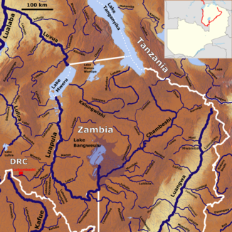
 Das Flusssystem des Luvua mit dem Kalungwishi (Mitte) | ||
Der Kalungwishi ist ein Fluss in Sambia. Er gehört zum Flusssystem des Kongo.