Back خليج نيويورك السفلي Arabic Lower New York Bay Catalan Lower Bay (luuk sa Tinipong Bansa, New Jersey) CEB Lower New York Bay English Lower New York Bay Estonian Lower New York Bay French מפרץ ניו יורק התחתון HE Lower New York Bay Italian ロウアー・ニューヨーク湾 Japanese Lower New York Bay Portuguese
| Lower New York Bay | ||
|---|---|---|
 Strand der Bucht vom Wolfe’s Pond Park | ||
| Gewässer | Atlantischer Ozean | |
| Landmasse | Staten Island, Long Island | |
| Geographische Lage | 40° 31′ N, 74° 3′ W | |
| Breite | 32 km | |
| Tiefe | 12 km | |
| Inseln | Hoffman Island, Swinburne Island | |
| Zuflüsse | Hudson River | |
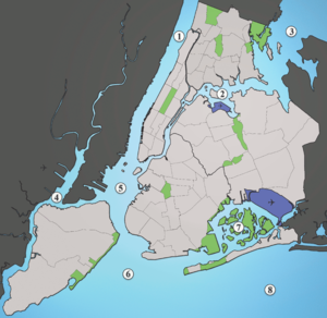
 1: Hudson River, 2: East River, 3: Long Island Sound, 4: Newark Bay, 5: Upper New York Bay, 6: Lower New York Bay, 7: Jamaica Bay, 8: Atlantik | ||
Die Lower New York Bay ist eine Bucht vor der Hafeneinfahrt von New York City. Mit der Upper New York Bay ist sie durch die Meeresenge The Narrows verbunden. Sie ist der äußere Teil der New York Bay und verbindet den Hafen von New York mit dem Atlantik.
