Back Manapouri CEB Manapouri English Manapouri Italian Manapouri Malay Manapouri Dutch Manapouri (miejscowość) Polish Manapouri Portuguese
| Manapouri Māori: Manapōuri | ||
| Geographische Lage | ||
| Koordinaten | 45° 34′ S, 167° 37′ O | |
| Region-ISO | NZ-STL | |
| Staat | ||
| Region | Southland | |
| Distrikt | Southland District | |
| Ward | Te Anau Ward | |
| Einwohner | 228 (2013[1]) | |
| Höhe | 200 m | |
| Postleitzahl | 9643 | |
| Telefonvorwahl | +64 (0)3 | |
| UN/LOCODE | NZ MNP | |
| Webseite | www.manapouri.nz.com | |
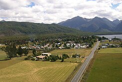
| Fotografie des Ortes | ||
 Manapouri | ||
Manapouri (Maori Manapōuri) ist ein Dorf im Southland District der Region Southland auf der Südinsel von Neuseeland.
- ↑ Referenzfehler: Ungültiges
<ref>-Tag; kein Text angegeben für Einzelnachweis mit dem Namen Stat_NZ_Population_and_dwellings.
