Back Sacramento Afrikaans ሳክራመንቶ Amharic Sacramento (California) AN Hālgþingstede ANG ساكرامنتو (كاليفورنيا) Arabic ساكرامنتو (كاليفورنيا) ARZ Sacramento AST Sakramento (Kaliforniya) Azerbaijani ساکرامنتو AZB Sacramento, California BAN
| Sacramento | |
|---|---|
| Spitzname: Sac, Sac-Town, Old Sac, The Big Tomato[1][2] | |
 | |
 |
 |
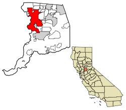
| Lage im Sacramento County und in Kalifornien | |
| Basisdaten | |
| Gründung: | 1849 |
| Staat: | Vereinigte Staaten |
| Bundesstaat: | Kalifornien |
| County: | Sacramento County |
| Koordinaten: | 38° 35′ N, 121° 29′ W |
| Zeitzone: | Pacific (UTC−8/−7) |
| Einwohner: – Metropolregion: |
524.943 (Stand: 2020) 2.397.382 (Stand: 2020) |
| Haushalte: | 187.683 (Stand: 2020) |
| Fläche: | 257 km² (ca. 99 mi²) davon 251,6 km² (ca. 97 mi²) Land |
| Bevölkerungsdichte: | 2.086 Einwohner je km² |
| Höhe: | 8 m |
| Postleitzahlen: | 942xx, 958xx |
| Vorwahl: | +1 916 |
| FIPS: | 06-64000 |
| GNIS-ID: | 1659564 |
| Website: | www.cityofsacramento.org |
| Bürgermeister: | Kevin McCarty[3] |
Sacramento [] ist die Hauptstadt des US-Bundesstaates Kalifornien. Die Stadt liegt im Zentrum des Sacramento Valley, an der Mündung des American River in den Sacramento River und hat 524.943 Einwohner (2020, U.S. Census Bureau).[4]
- ↑ Sacramento’s canning industry canned every imaginable farm product, but tomatoes were the best-known, earning Sacramento the nickname „The Big Tomato.“The Big Tomato – Midtown, Sacramento Monthly
- ↑ Leland, Kupcha: The big tomato – Sacramento: a guide to California's capital city, 1984
- ↑ www.cityofsacramento.gov. (abgerufen am 13. Dezember 2024).
- ↑ U.S. Census Bureau QuickFacts: Sacramento city, California. In: census.gov. Abgerufen am 23. März 2024.
