Back Southland District CEB Southland District English Distrito Southland Spanish District de Southland French Distretto di Southland Italian Daerah Southland Malay Southland District NN ضلع ساؤتھلینڈ PNB Southland District Swedish
| Southland District Māori: Te Rohe Pōtae O Murihiku | |
| Geographische Lage | |
 Lage des Southland District | |
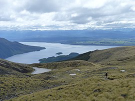
| Foto vom Southland District | |
 Blick auf den South Fiord (vorne links) und den Lake Te Anau (hinten links und rechts) vom Kepler Track | |
| Gebietskörperschaft | |
| Staat | Neuseeland |
| Insel | Südinsel |
| Region | Southland |
| Gebietskörperschaft | District |
| Council (Rat) | Southland District Council |
| Sitz der Verwaltung | Invercargill |
| Bürgermeister | Rob Scott |
| Gründung | 1989 |
| Postleitzahl | 9583, 9586, 9600, 9610, 9620, 9630, 9635, 9672, 9679, 9681–9683, 9691, 9720, 9730, 9774–9779, 9781–9783, 9792–9794, 9816, 9822, 9825, 9831, 9871, 9872 9874–9877, 9883, 9884, 9892[1] |
| Telefonvorwahl | +64 (0)3 |
| Website | www.southlanddc.govt.nz |
| Präsentation | |
| Wahlspruch | People First (Menschen zuerst) |
| Geographie | |
| Region-ISO | NZ-STL |
| Koordinaten | 46° 25′ S, 168° 21′ O |
| Höchste Erhebung | 2536 m |
| Niedrigster Punkt | Höhe Meeresspiegel |
| Fläche | 29 552 km2 |
| Einwohner | 29 613 (2013[2]) |
| Bevölkerungsdichte | 1 Einw. pro km2 |
| Statistische Daten | |
| Öffentl. Einnahmen | 57,9 Mio. NZ$ (2015[3]) |
| Öffentl. Ausgaben | 63,0 Mio. NZ$ (2015[3]) |
| Anzahl Haushalte | 14 886 (2013[2]) |
| Ø Einkommen | 33.900 NZ$ (2013[3]) |
| Bevölkerungsanteil Māori | 9,6 % (2013[2]) |
Der Southland District ist eine zur Region Southland gehörende Verwaltungseinheit in Neuseeland. Der Rat des Distrikts, Southland District Council (Distriktrat) genannt, hat seinen Sitz in der Stadt Invercargill City, ebenso wie die Verwaltung des Distrikts.
- ↑ Referenzfehler: Ungültiges
<ref>-Tag; kein Text angegeben für Einzelnachweis mit dem Namen Postcode_Boundaries. - ↑ a b c Referenzfehler: Ungültiges
<ref>-Tag; kein Text angegeben für Einzelnachweis mit dem Namen Statistics_NZ_Population_Dwellings. - ↑ a b c Referenzfehler: Ungültiges
<ref>-Tag; kein Text angegeben für Einzelnachweis mit dem Namen Local_Councils_About.