Back خليج نيويورك العلوي Arabic Верхняя Нью-Ёркская бухта Byelorussian ऊपरी न्यू यॉर्क खाड़ी Bihari Upper New York Bay Catalan Ibabawng Luok sa Bag-ong York CEB Upper New York Bay English Golfeto Alta Novjorko Esperanto Bahía Upper New York Spanish Upper New York Bay Estonian خلیج بالای نیویورک Persian
| Upper New York Bay | ||
|---|---|---|
 Schiffe in der Upper New York Bay | ||
| Gewässer | Atlantischer Ozean | |
| Landmasse | Long Island, Manhattan, New Jersey | |
| Geographische Lage | 40° 40′ 6″ N, 74° 2′ 44″ W | |
| Breite | 6 km | |
| Tiefe | 9,5 km | |
| Inseln | Governors Island, Liberty Island, Ellis Island | |
| Zuflüsse | Hudson River, East River, Kill Van Kull | |
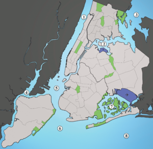
 1: Hudson River, 2: East River, 3: Long Island Sound, 4: Newark Bay, 5: Upper New York Bay, 6: Lower New York Bay, 7: Jamaica Bay, 8: Atlantic Ocean | ||
Die Upper New York Bay ist eine Bucht südlich von Manhattan in den US-Bundesstaaten New York und New Jersey. Sie ist der nördliche Teil der New York Bay, die weiterhin aus der Lower New York Bay und dem Kanal The Narrows, der die beiden Buchten verbindet, besteht. Die Upper New York Bay bildet den zentralen Teil des Hafens von New York.
