Back Water of Leith (suba sa Hiniusang Gingharian) CEB Water of Leith Danish Water of Leith English Water of Leith Spanish Water of Leith Basque Water of Leith French Uisge Lìte Scots/Gaelic Water of Leith Polish Water of Leith PMS Water of Leith Portuguese
| Water of Leith | ||
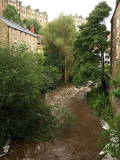
 In Dean Village nordwestlich vom Stadtzentrum von Edinburgh | ||
| Daten | ||
| Lage | Schottland, Vereinigtes Königreich | |
| Flusssystem | Water of Leith | |
| Ursprung | Pentland Hills 55° 47′ 36″ N, 3° 28′ 15″ W | |
| Quellhöhe | ca. 405 m ASL | |
| Mündung | im Hafen von Leith in den Firth of Forth (Nordsee)Koordinaten: 55° 59′ 21″ N, 3° 10′ 58″ W 55° 59′ 21″ N, 3° 10′ 58″ W | |
| Mündungshöhe | 0 m ASL | |
| Höhenunterschied | ca. 405 m | |
| Sohlgefälle | ca. 11 ‰ | |
| Länge | 36,2 km[1][2][3][4] | |
| Durchflossene Stauseen | Harperrig Reservoir | |
| Großstädte | Edinburgh | |
Das Water of Leith, auch Leith Water, schottisch-gälisch Uisge Lìte, ist der wichtigste Flusslauf von Edinburgh, Schottland.
- ↑ Water of Leith (Source to Harperrig Reservoir), Scottish Environment Protection Agency.
- ↑ Water of Leith (Harperrig Reservoir to Poet’s Burn confluence), Scottish Environment Protection Agency.
- ↑ Water of Leith (Poet’s Burn to Murray Burn confluences), Scottish Environment Protection Agency.
- ↑ Water of Leith (Murray Burn confluence to Estuary), Scottish Environment Protection Agency.