Back 1997年の台風 Japanese 1997년 태풍 Korean Tyfoonseizoen van de Grote Oceaan 1997 Dutch Temporada de tufões no Pacífico de 1997 Portuguese 1997 Pacific typhoon season SIMPLE Mùa bão Tây Bắc Thái Bình Dương 1997 Vietnamese 1997年太平洋颱風季 Chinese
| 1997 Pacific typhoon season | |
|---|---|
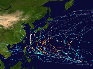
 Season summary map | |
| Seasonal boundaries | |
| First system formed | January 19, 1997 |
| Last system dissipated | December 23, 1997 |
| Strongest storm | |
| By maximum sustained winds | Keith |
| • Maximum winds | 205 km/h (125 mph) (10-minute sustained) |
| • Lowest pressure | 910 hPa (mbar) |
| By central pressure | Ivan and Joan |
| • Maximum winds | 195 km/h (120 mph) (10-minute sustained) |
| • Lowest pressure | 905 hPa (mbar) |
| Seasonal statistics | |
| Total depressions | 47 |
| Total storms | 28 |
| Typhoons | 16 |
| Super typhoons | 11 (unofficial)[nb 1] (record high tied with 1965) |
| Total fatalities | 4,036 total |
| Total damage | > $4.59 billion (1997 USD) |
| Related articles | |
The 1997 Pacific typhoon season was a record-breaking season featuring eleven tropical cyclones reaching super typhoon intensity, tying the record with 1965 with the most intense tropical cyclones globally, and was the ninth and last consecutive year of above-average tropical cyclone activity that started in 1989. Its extremely high activity produced highest ACE index ever index recorded in a single tropical cyclone season. In addition, this season had ten Saffir-Simpson Category 5-equivalent tropical cyclones, the most ever recorded, even greater than the 2005 Atlantic hurricane season, and 2020 Atlantic hurricane season, for Category 4, which had nearly half of the amount. The 1997–98 El Niño event was a contributing factor to this unusually high activity. Despite this, the season produced an average number of tropical storms, spawning 28 tropical storms.
It has no official bounds; it ran year-round in 1997, but most tropical cyclones tend to form in the northwestern Pacific Ocean between May and November.[1] These dates conventionally delimit the period of each year when most tropical cyclones form in the northwestern Pacific Ocean. The first named storm, Hannah, developed on January 20 while the last named storm, Paka, dissipated on December 23. Tropical Storm Linda became the worst tropical cyclone to hit Vietnam, killing over 3,000 people.
The scope of this article is limited to the Pacific Ocean to the north of the equator between 100°E and 180th meridian. Within the northwestern Pacific Ocean, there are two agencies which assign names to tropical cyclones which can often result in a cyclone having two names. The Japan Meteorological Agency (JMA)[nb 2] will name a tropical cyclone if it has 10-minute sustained wind speeds of at least 65 km/h (40 mph) anywhere in the basin, while the Philippine Atmospheric, Geophysical and Astronomical Services Administration (PAGASA) assigns names to tropical cyclones which are active in the Philippine Area of Responsibility (PAR), located between 135°E and 115°E and between 5°N–25°N, regardless of whether or not a tropical cyclone has already been given a name by the JMA. Tropical depressions that are monitored by the United States' Joint Typhoon Warning Center (JTWC)[nb 3][nb 1] are given a number with a "W" suffix.
Cite error: There are <ref group=nb> tags on this page, but the references will not show without a {{reflist|group=nb}} template (see the help page).
- ^ Gary Padgett. May 2003 Tropical Cyclone Summary. Archived September 25, 2006, at the Wayback Machine Retrieved on 2006-08-26.
- ^ "Joint Typhoon Warning Center Mission Statement". Joint Typhoon Warning Center. 2011. Archived from the original on July 26, 2007. Retrieved July 25, 2012.
- ^ Frequently Asked Questions (Report). Joint Typhoon Warning Center. August 13, 2012. Archived from the original on October 4, 2013. Retrieved September 22, 2012.