Back Ruta 2 del metro de Nova York Catalan U-Bahn-Linie 2 (New York City) German 2 (metro de Nueva York) Spanish Linja 2 (New Yorkin metro) Finnish Ligne 2 du métro de New York French קו 2 של הרכבת התחתית של ניו יורק HE Linea 2 (metropolitana di New York) Italian ニューヨーク市地下鉄2系統 Japanese 뉴욕 지하철 2호선 Korean Linia 2 (metropolitana de Noeuva York) LMO
The 2 Seventh Avenue Express[3] is a rapid transit service in the A Division of the New York City Subway. Its route emblem, or "bullet", is colored red since it uses the IRT Broadway–Seventh Avenue Line through most of Manhattan.
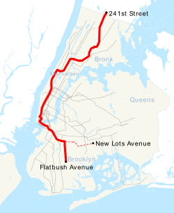
The 2 operates 24 hours a day between 241st Street in Wakefield, Bronx, and Flatbush Avenue–Brooklyn College in Flatbush, Brooklyn; limited rush hour service in the reverse-peak direction originates and terminates at New Lots Avenue in East New York, Brooklyn instead of Flatbush Avenue.[4][5][a] Daytime service makes express stops in Manhattan (between 96th and Chambers Streets) and all stops in the Bronx and Brooklyn; overnight service makes all stops along the full route.
Historically, 2 trains have also run to Crown Heights–Utica Avenue or New Lots Avenue. They ran exclusively on the IRT New Lots Line until 1983, when the 2 was routed to Flatbush Avenue. This is still the case with some rush-hour trains, albeit just to New Lots Avenue.
- ^ 'Subdivision 'A' Car Assignment Effective December 23, 2023'. New York City Transit, Operations Planning. December 23, 2023.
- ^ "Subdivision 'A' Car Assignments: Cars Required December 23, 2023" (PDF). The Bulletin. 67 (2). Electric Railroaders' Association. February 2024. Retrieved March 22, 2024.
- ^ "2 Subway Timetable, Effective June 26, 2022". Metropolitan Transportation Authority. Retrieved December 16, 2024.
- ^ "7:40 AM – 9:35 AM New Lots Av – OpenMobilityData". transitfeeds.com. August 8, 2021. Archived from the original on August 8, 2021. Retrieved August 8, 2021.
- ^ "3:42 PM – 5:30 PM Wakefield-241 St – OpenMobilityData". transitfeeds.com. August 8, 2021. Archived from the original on August 8, 2021. Retrieved August 8, 2021.
- ^ "7:21 AM – 9:07 AM Wakefield-241 St – OpenMobilityData". transitfeeds.com. August 8, 2021. Archived from the original on August 8, 2021. Retrieved August 8, 2021.
Cite error: There are <ref group=lower-alpha> tags or {{efn}} templates on this page, but the references will not show without a {{reflist|group=lower-alpha}} template or {{notelist}} template (see the help page).


