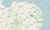
| A146 | |
|---|---|
Click map to enlarge | |
| Route information | |
| Length | 27 mi (43 km) |
| Major junctions | |
| North-west end | Norwich (A140) 52°36′46″N 1°16′54″E / 52.6127°N 1.2818°E |
B1332 to Bungay B1136 to Great Yarmouth | |
| South-east end | Lowestoft (A1117) 52°28′07″N 1°42′25″E / 52.4687°N 1.7070°E |
| Location | |
| Country | United Kingdom |
| Primary destinations | Beccles |
| Road network | |
The A146 is an A road that connects Norwich in Norfolk and Lowestoft in Suffolk, two of East Anglia's largest population centres. It is around 27 miles (43 km) in length and has primary classification along its entire route. It is mainly single carriageway throughout its route, with the exception of a section of dual carriageway on the southern edge of Norwich.


