| A38 | ||||
|---|---|---|---|---|
 | ||||
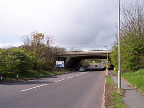
 A38 passing under M50 in Worcestershire | ||||
| Route information | ||||
| Length | 292 mi (470 km) | |||
| Major junctions | ||||
| South end | ||||
| North end | ||||
| Location | ||||
| Country | United Kingdom | |||
| Primary destinations | Bodmin Liskeard Plymouth Exeter Taunton Bridgwater Bristol Gloucester Worcester Bromsgrove Birmingham Lichfield Burton upon Trent Derby Mansfield | |||
| Road network | ||||
| ||||
The A38, parts of which are known as Devon Expressway, Bristol Road and Gloucester Road, is a major A-class trunk road in England.
The road runs from Bodmin in Cornwall to Mansfield in Nottinghamshire. It is 292 miles (470 km) long, making it the longest two digit A road in England. It was formerly known as the Leeds–Exeter Trunk Road, when this description also included the A61. Before the opening of the M5 motorway in the 1960s and 1970s, the A38 formed the main "holiday route" from the Midlands to Somerset, Devon and Cornwall.
Considerable lengths of the road in the West Midlands closely follow Roman roads,[1][2][3] including part of Icknield Street.[4] Between Worcester and Birmingham the current A38 follows the line of a Saxon salt road.[5]
For most of the length of the M5 motorway, the A38 road runs alongside it as a single carriageway road.
- ^ Margary (1973), pp. 140–141
- ^ Margary (1973), pp. 287–288
- ^ Cite error: The named reference
Margary305was invoked but never defined (see the help page). - ^ Taylor (1979), p. 190
- ^ Taylor (1979), p. 96

