Back ABC-eilande Afrikaans جزر الأي بي سي (جزر الأنتيل الصغرى) Arabic Illes ABC Catalan Ynysoedd ABC Welsh ABC-øerne Danish ABC-Inseln German ABC νησιά (Καραϊβική) Greek ABC-insuloj Esperanto Islas ABC Spanish ABC saared Estonian
12°16′N 69°05′W / 12.27°N 69.08°W
ABC Islands
| |
|---|---|
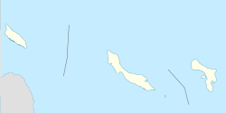
 From left to right, Aruba, Curaçao, and Bonaire | |
Location of ABC islands in the Leeward Antilles | |
| Capitals | 3 capitals |
| Languages | 3 languages |
| Demonym(s) | |
| Islands | |
| Area | |
• Total | 912 km2 (352 sq mi) |
| Population | |
• 2022 estimate | 300.000 |
• Density | 298/km2 (771.8/sq mi) |
| GDP (PPP) | estimate |
• Total | $15.977 billion |
• Per capita | $47,683 |
| GDP (nominal) | estimate |
• Total | $18.852 billion |
• Per capita | $47,113 |
| HDI | 0.833 very high |
| Currency | |
| Today part of | The Kingdom Of The Netherlands |
The ABC islands is the physical group of Aruba, Bonaire, and Curaçao, the three westernmost islands of the Leeward Antilles in the Caribbean Sea. These islands have a shared political history and a status of Dutch underlying ownership, since the Anglo-Dutch Treaty of 1814 ceded them back to the Kingdom of the Netherlands, as Curaçao and Dependencies from 1815. They are a short distance north of the Falcón State, Venezuela.[1] Aruba and Curaçao are autonomous, self governing constituent countries of the Kingdom of the Netherlands, while Bonaire is a special municipality of the Netherlands. Territories of the Kingdom of the Netherlands, the countries, and its special municipalities, are outside the European Union; citizens have Dutch nationality and the former colonial power benefits from preferential trade, mineral and natural resource rights, particularly offshore.
- ^ Miller, Debra (2005). Caribbean Islands (Lonely Planet) (4th ed.). Lonely Planet. p. 723. ISBN 978-1-74104-055-5.