Back Aguachica AVK Aguachica (munisipyo) CEB Aguachica German Aguachica Spanish اگواچیکا Persian Aguachica French Aguachica Italian აგუაჩიკა Georgian Aguachica Malagasy Aguachica Malay
Aguachica | |
|---|---|
Municipality and city | |
 | |
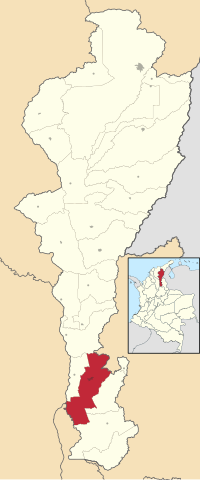
 Location in the Department of Cesar. Municipality (red), City (dark gray). | |
| Coordinates: 8°18′45″N 73°37′37″W / 8.31250°N 73.62694°W | |
| Country | Colombia |
| Region | Caribbean |
| Department | Cesar |
| Foundation | August 16, 1748 |
| Government | |
| • Mayor | Vacant |
| Area | |
• Municipality and city | 877.7 km2 (338.9 sq mi) |
| • Urban | 10.85 km2 (4.19 sq mi) |
| Elevation | 162 m (531 ft) |
| Population (2020 est.)[1] | |
• Municipality and city | 118,652 |
| • Density | 140/km2 (350/sq mi) |
| • Urban | 103,209 |
| • Urban density | 9,500/km2 (25,000/sq mi) |
| Time zone | UTC-5 |
| Area code | 57 + 5 |
| Website | Official website (in Spanish) |
Aguachica (Spanish pronunciation: [aɣwaˈtʃika]), is a city and municipality in the southern region of the Cesar Department, Colombia, located between the inter-Andean valley of Magdalena Medio and the Motilones. It is the second most populated municipality in the department and an important livestock and commercial center in the southeast of the Colombian Caribbean.
In terms of transportation infrastructure, its geographically strategic position connects the Colombian Caribbean with the Santanderes through the Ruta del Sol, and is also a key communication point for the Catatumbo region via National Route 70. It also has air transportation through the Hacaritama Airport, a railway system, and in parallel with the Magdalena River waterway through the port of Gamarra. [2]
- ^ Citypopulation.de Population of Aguachica municipality
- ^ "Plan de Desarrollo Municipio de Aguachica-Cesar (in Spanish) - Aguachica-Cesar Municipality Development Plan" (PDF). Centro Documental e Información Municipal – CDIM, 2012. Retrieved February 10, 2023.

