Back أغيلار (كولورادو) Arabic اجيلار ARZ آقویلار، کولورادو AZB Агилар (Колорадо) CE Aguilar (lungsod) CEB Aguilar, Colorado Welsh Aguilar (Colorado) Spanish Aguilar (Colorado) Basque آگویلار، کلرادو Persian Aguilar (Colorado) French
Aguilar, Colorado | |
|---|---|
 Old building on main street of Aguilar, 1946. | |
| Motto: "Gateway to the Spanish Peaks" | |
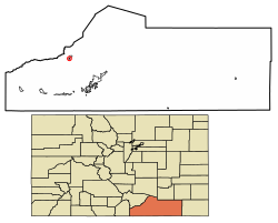
 Location of the Town of Aguilar in Las Animas County, Colorado. | |
| Coordinates: 37°24′10″N 104°39′12″W / 37.4028°N 104.6533°W[3] | |
| Country | United States |
| State | Colorado |
| County | Las Animas[2] |
| Founded | 1894 |
| Incorporated (town) | January 10, 1894[4] |
| Government | |
| • Type | Statutory Town[1] |
| • Mayor | Marc Piano [citation needed] |
| Area | |
• Total | 0.39 sq mi (1.02 km2) |
| • Land | 0.39 sq mi (1.02 km2) |
| • Water | 0.00 sq mi (0.00 km2) |
| Elevation | 6,388 ft (1,947 m) |
| Population (2020) | |
• Total | 456 |
| • Density | 1,163.27/sq mi (448.79/km2) |
| Time zone | UTC−07:00 (MST) |
| • Summer (DST) | UTC−06:00 (MDT) |
| ZIP code | 81020[6] |
| Area code | 719 |
| FIPS code | 08-00760 |
| GNIS pop ID | 194464 |
| GNIS town ID | 2412339 |
| Website | aguilarco |
Aguilar is a Statutory Town located in Las Animas County, Colorado, United States.[1] The town population was 456 at the 2020 United States Census.[7] Cattleman and prominent pioneer José Ramón Aguilar founded the town in 1894.[8][9]
- ^ a b c "Active Colorado Municipalities". Colorado Department of Local Affairs. Retrieved December 29, 2024.
- ^ "Colorado Counties". Colorado Department of Local Affairs. Retrieved January 10, 2025.
- ^ a b "Aguilar, Colorado". Geographic Names Information System. United States Geological Survey, United States Department of the Interior. Retrieved January 10, 2025.
- ^ "Colorado Municipal Incorporations". State of Colorado, Department of Personnel & Administration, Colorado State Archives. December 1, 2004. Archived from the original on September 27, 2007. Retrieved August 18, 2007.
- ^ "2020 U.S. Gazetteer Files". United States Census Bureau. Retrieved October 31, 2021.
- ^ "ZIP Code Lookup". United States Postal Service. August 18, 2007. Archived from the original (JavaScript/HTML) on August 18, 2007. Retrieved August 18, 2007.
- ^ "Decennial Census P.L. 94-171 Redistricting Data". United States Census Bureau, United States Department of Commerce. August 12, 2021. Retrieved September 2, 2021.
- ^ "Geographic Names Information System Feature Detail Report". USGS. Retrieved August 18, 2007.
- ^ "The Jose Ramon Aguilar Story". Centennial Aguilar Booklet 1994. Apishapa Valley Historical Society. Archived from the original on September 14, 2007. Retrieved August 18, 2007.