Back ألاباها (جورجيا) Arabic الاباها ARZ آلاپاها، جورجیا AZB Alapaha Catalan Алапага (Джорджи) CE Alapaha CEB Alapaha (Georgie) Czech Alapaha, Georgia Welsh Alapaha Spanish Alapaha (Georgia) Basque
Alapaha, Georgia | |
|---|---|
 Alapaha City Hall | |
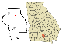
 Location in Berrien County and the state of Georgia | |
| Coordinates: 31°22′56″N 83°13′26″W / 31.38222°N 83.22389°W | |
| Country | United States |
| State | Georgia |
| County | Berrien |
| Area | |
• Total | 1.03 sq mi (2.66 km2) |
| • Land | 1.03 sq mi (2.66 km2) |
| • Water | 0.00 sq mi (0.00 km2) |
| Elevation | 285 ft (87 m) |
| Population (2020) | |
• Total | 481 |
| • Density | 468.35/sq mi (180.80/km2) |
| Time zone | UTC-5 (Eastern (EST)) |
| • Summer (DST) | UTC-4 (EDT) |
| ZIP code | 31622 |
| Area code | 229 |
| FIPS code | 13-01024[2] |
| GNIS feature ID | 0331009[3] |
Alapaha is a town in Berrien County, Georgia, United States, along the Alapaha River. As of the 2020 census, the city had a population of 481.
Alapaha developed from a trade settlement on the site of a Seminole village with the same name. The present-day Georgia town of Lakeland was originally named "Alapaha" and existed before the town that now bears the name.[4]
- ^ "2020 U.S. Gazetteer Files". United States Census Bureau. Retrieved December 18, 2021.
- ^ "U.S. Census website". United States Census Bureau. Retrieved January 31, 2008.
- ^ "US Board on Geographic Names". United States Geological Survey. October 25, 2007. Retrieved January 31, 2008.
- ^ Ken Krakow, Place Names of Georgia, Winship Press, 1975.