| Ward of Aldgate | |
|---|---|
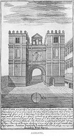
 Print of the Aldgate, around 1609 | |
Location within Greater London | |
| OS grid reference | TQ334813 |
| • Charing Cross | 2.3 mi (3.7 km) WSW |
| Sui generis | |
| Administrative area | Greater London |
| Region | |
| Country | England |
| Sovereign state | United Kingdom |
| Post town | LONDON |
| Postcode district | EC3 |
| Postcode district | E1 |
| Dialling code | 020 |
| Police | City of London |
| Fire | London |
| Ambulance | London |
| UK Parliament | |
| London Assembly | |
Aldgate (/ˈɔːlɡeɪt/) was a gate in the former defensive wall around the City of London.
The gate gave its name to Aldgate High Street, the first stretch of the A11 road, that takes that name as it passes through the ancient, extramural Portsoken Ward of the City of London.
There is an ancient Aldgate Ward inside the line of the former gate and wall, and a similarly ancient Portsoken Ward that lies just outside of it. However the use of the Aldgate and Portsoken Wards as everyday place names is very limited.
Consequently, the use of Aldgate as a place name is informal, and typically applies to the Portsoken Ward, especially the central area around Aldgate High Street.
Aldgate High Street is 2.3 miles (3.7 km) east of Charing Cross.

