Back আলফ্রেডো ৱআগনের্ BPY Алфреду-Вагнер CE Alfredo Wagner CEB Alfredo Wagner Spanish Alfredo Wagner Basque الفردو واگنر Persian Alfredo Wagner French Alfredo Wagner Interlingua Alfredo Wagner Italian ალფრედუ-ვაგნერი Georgian
This article's tone or style may not reflect the encyclopedic tone used on Wikipedia. (January 2025) |
Alfredo Wagner
Alfredense The Municipality of Alfredo Wagner | |
|---|---|
Municipality | |
| Nickname: Sources of Capital | |
 | |
| Coordinates: 27°42′00″S 49°20′02″W / 27.70000°S 49.33389°W | |
| Country | |
| Region | South |
| State | Santa Catarina |
| Mesoregion | Great Florianópolis |
| Microregion | Tabuleiro |
| Founded | December 21, 1961 |
| Mesoregion date | IBGE/2008[1] |
| Micoregion date | IBGE/2008[1] |
| Government | |
| • Mayor | Naudir Antonio Schmitz[2] (PMDB) |
| Population (2020 [3]) | |
• Total | 10,086 |
| Time zone | UTC−3 (BRT) |
| Postal Code | 88450-000 |
| Area code | (48) |
| Nearby towns | Angelina, Anitápolis, Bom Retiro, Chapadão do Lageado, Imbuia, Ituporanga, Leoberto Leal e Rancho Queimado |
| Distance to the capital | 78.1 km (48.5 mi) |
| Website | www.alfredowagner.sc.gov.br |
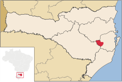
Alfredo Wagner is a municipality in the state of Santa Catarina in the South region of Brazil.[1][4][5][6]
The municipality contains the Rio das Furnas Private Natural Heritage Reserve, created in 2002.[7]
The first attempts of colonizing Alfredo Wagner were made at nineteen military in the Morro do Trombudo. The expedition was unsuccessful because snow was abundant and the rain in the three years ravaged the region. Augusto Lima, in 1893, settled in Rivers Adaga and Caeté, accompanied by some settlers. The local passed the name "Barracão", the first name of "Alfredo Wagner". The name is a homage to the men of more worked for emancipation political-administrative the municipality, dismembering of Bom Retiro.[clarification needed]
- ^ a b c "Divisão Territorial do Brasil". Divisão Territorial do Brasil e Limites Territoriais (in Portuguese). Instituto Brasileiro de Geografia e Estatística (IBGE). July 1, 2008. Retrieved October 11, 2008.
- ^ "Eleições 2012 - Alfredo Wagner / SC" (in Portuguese). Resultado eleições municipais do Brasil 2012 do Tribunal Regional Eleitoral de Santa Catarina (TRE/SC). Archived from the original on March 3, 2016. Retrieved January 24, 2013.
- ^ IBGE 2020
- ^ "Estimativas da população para 1º de julho de 2009" (PDF) (in Portuguese). Estimativas de População, Instituto Brasileiro de Geografia e Estatística (IBGE). August 14, 2009. Retrieved December 17, 2009.
- ^ "Ranking decrescente do IDH-M dos municípios do Brasil" (in Portuguese). Atlas do Desenvolvimento Humano, Programa das Nações Unidas para o Desenvolvimento (PNUD). 2000. Archived from the original on October 3, 2009. Retrieved December 17, 2009.
- ^ "Produto Interno Bruto dos Municípios 2002-2005" (PDF) (in Portuguese). Instituto Brasileiro de Geografia e Estatística (IBGE). December 19, 2007. Archived from the original (PDF) on October 2, 2008. Retrieved December 17, 2009.
- ^ RPPN Reserva Rio das Furnas (in Portuguese), ICMBio, retrieved 2017-03-14

