| Allenby Formation | |
|---|---|
| Stratigraphic range: Ypresian | |
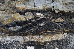
 Alternating Princeton Chert and coal sequences | |
| Type | Geological formation |
| Unit of | Princeton Group, Eocene Okanagan Highlands |
| Sub-units | Princeton Chert, Vermillion Bluffs Shale |
| Overlies | Cedar Formation |
| Area | 300 km2 (120 sq mi)[1] |
| Thickness | 1,860–2,100 m (6,100–6,890 ft)[1] |
| Lithology | |
| Primary | Shale, sandstone |
| Other | Coal–breccia, coal–chert |
| Location | |
| Coordinates | 49°22.6′N 120°32.8′W / 49.3767°N 120.5467°W |
| Approximate paleocoordinates | 53°06′N 107°30′W / 53.1°N 107.5°W |
| Region | British Columbia |
| Country | |
| Extent | Princeton Basin & Tulameen basin |
| Type section | |
| Named for | Allenby, British Columbia |
| Named by | Shaw |
| Year defined | 1952 |
The Allenby formation is a sedimentary rock formation in British Columbia which was deposited during the Ypresian stage of the Early Eocene. It consists of conglomerates, sandstones with interbedded shales and coal. The shales contain an abundance of insect, fish and plant fossils known from 1877 and onward, while the Princeton Chert was first indented in the 1950s and is known from anatomically preserved plants.
There are several notable fossil producing localities in the Princeton & Tulameen basins. Historical collection sites included Nine Mile Creek, Vermilian Bluffs, and Whipsaw Creek, while modern sites include One Mile Creek, Pleasant Valley, Thomas Ranch, and the Princeton Chert.


