Back Altay (şəhər) Azerbaijani Алтай BXR Aletai Catalan Altay (kapital sa gatos) CEB Altay (Stadt) German Αλτάι (πόλη) Greek Altái (Sinkiang) Spanish شهر آلتای Persian Altay (Xinjiang) Finnish Altay (Xinjiang) French
This article needs additional citations for verification. (December 2021) |
Altay
| |
|---|---|
 | |
 | |
| Coordinates (Altay City government): 47°49′37″N 88°07′51″E / 47.82694°N 88.13083°E | |
| Country | China |
| Autonomous region | Xinjiang |
| Prefecture | Altay |
| Municipal seat | Tuanjie Road Subdistrict |
| Area | |
| 11,400 km2 (4,400 sq mi) | |
| Elevation | 887 m (2,910 ft) |
| Population (2020)[1] | |
| 221,454 | |
| • Density | 19/km2 (50/sq mi) |
| • Urban (2016)[2] | 114,995 |
| • Rural (2016)[2] | 83,945 |
| Time zone | UTC+8 (China Standard[a]) |
| Postal code | 836500 |
| Area code | 0906 |
| GDP (Nominal) | 2016[2] |
| - Total | ¥6.483 billion US$1.007 billion |
| - per capita | ¥32.574 US$5.060 |
| Website | Altay City Government Website |
| Altay City | |||||||||||
|---|---|---|---|---|---|---|---|---|---|---|---|
| Chinese name | |||||||||||
| Chinese | 阿勒泰 | ||||||||||
| |||||||||||
| Alternative Chinese name | |||||||||||
| Chinese | 承化寺 | ||||||||||
| |||||||||||
| Mongolian name | |||||||||||
| Mongolian Cyrillic | Алтай хот | ||||||||||
| Mongolian script | ᠠᠯᠲᠠᠢ ᠬᠣᠲᠠ | ||||||||||
| |||||||||||
| Uyghur name | |||||||||||
| Uyghur | ئالتاي | ||||||||||
| |||||||||||
| Kazakh name | |||||||||||
| Kazakh | التاي قالاسى Altai qalası Алтай қаласы | ||||||||||
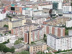
Altay or Aletai is a county-level city in Altay Prefecture within Ili Kazakh Autonomous Prefecture, in far Northern Xinjiang, China. The city centre is located on the banks of Kelan River.
- ^ "Xinjiang: Prefectures, Cities, Districts and Counties". Archived from the original on 2023-08-21. Retrieved 2023-08-22.
- ^ a b c "2016 Altay City National Economic and Social Development Statistical Communique". Retrieved 17 June 2018.[permanent dead link]
Cite error: There are <ref group=lower-alpha> tags or {{efn}} templates on this page, but the references will not show without a {{reflist|group=lower-alpha}} template or {{notelist}} template (see the help page).


