Back أموري (مسيسبي) Arabic امورى (مونرو) ARZ ایمری، میسیسیپی AZB Amory Catalan Эймори (Миссисипи) CE Amory CEB Amory, Mississippi Welsh Amory Spanish Amory (Mississippi) Basque ایمری، میسیسیپی Persian
Amory, Mississippi | |
|---|---|
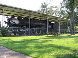
 Frisco Park in 2005 | |
 Location within Monroe County and the state of Mississippi | |
| Coordinates: 33°59′14″N 88°29′10″W / 33.98722°N 88.48611°W[1] | |
| Country | United States |
| State | Mississippi |
| County | Monroe |
| Government | |
| • Mayor | Corey Glenn (I)[2][3] |
| Area | |
• Total | 13.14 sq mi (34.03 km2) |
| • Land | 12.53 sq mi (32.46 km2) |
| • Water | 0.61 sq mi (1.58 km2) |
| Elevation | 240 ft (70 m) |
| Population | |
• Total | 6,666 |
| • Density | 531.96/sq mi (205.39/km2) |
| Time zone | UTC-6 (Central (CST)) |
| • Summer (DST) | UTC-5 (CDT) |
| ZIP Code | 38821 |
| Area code | 662 |
| FIPS code | 28-01260 |
| GNIS ID | 2403095[1] |
| Website | cityofamoryms |
Amory /ˈeɪ.mər.i/ is a city in Monroe County, Mississippi, United States. The population was 6,666 at the 2020 census, down from 7,316 in 2010. Located in the northeastern part of the state near the Alabama border, it was founded in 1887 as a railroad town by the Kansas City, Memphis and Birmingham Railroad. As a result, Cotton Gin Port, along the Tombigbee River to the east, was abandoned as businesses and people moved for railroad access.
- ^ a b c U.S. Geological Survey Geographic Names Information System: Amory, Mississippi
- ^ Dusen, Ray Van (June 8, 2021). "Glenn elected as Amory's mayor". Northeast Mississippi Daily Journal. Retrieved November 29, 2024.
- ^ "Official Recapitulation" (PDF). Mississippi Secretary of State. Retrieved November 28, 2024.
- ^ "2023 U.S. Gazetteer Files: Mississippi". United States Census Bureau. Retrieved March 8, 2024.
- ^ "P1. Race – Amory city, Mississippi: 2020 DEC Redistricting Data (PL 94-171)". U.S. Census Bureau. Retrieved March 8, 2024.

