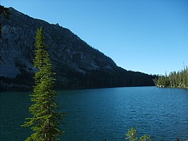
| Aneroid Lake | |
|---|---|
 Aneroid Lake northern view | |
| Location | Eagle Cap Wilderness, Wallowa County, Oregon, US |
| Coordinates | 45°12′30″N 117°12′15″W / 45.2082°N 117.2043°W |
| Type | |
| Primary inflows | Precipitation, basin drainage |
| Primary outflows | East Fork Wallowa River |
| Basin countries | United States |
| Max. length | 653 yd (597 m) |
| Max. width | 478 yd (437 m) |
| Surface area | 39 acres (16 ha) |
| Max. depth | 49 ft (15 m) |
| Shore length1 | 1.05 mi (1.69 km) |
| Surface elevation | 7,520 ft (2,290 m) |
| References | [1][2] |
| 1 Shore length is not a well-defined measure. | |
In common with many of the neighboring lakes in the Eagle Cap Wilderness of the Wallowa-Whitman National Forest in Wallowa County, Oregon, Aneroid Lake is nestled in an example of a cirque valley with large tarn scoured out of the mountain side by glacial movements during the Pleistocene.[3][4][5] Located at the southern foot of Bonneville Mountain the lake and its basin form the headwaters of the East Fork Wallowa River. Aneroid Mountain, namesake of the lake, is about 1.5 miles (2.4 km) to the east,[6] while Roger Lake lies in between a mere .5 miles (0.80 km) away. Dollar Lake is 1.5 miles (2.4 km) to the southeast and Pete's Point 1.5 miles (2.4 km) slightly to the southwest.[7] Because the lake is within the boundaries of the Eagle Cap Wilderness protection area it is inaccessible by any motorized vehicle or any other mechanized mode of travel.[8] However, there is a popular hiking trail for horse and foot traffic. A small group of private cabins that predate the wilderness designation are located beyond the south end of the lake. Aneroid Lake ties with Laverty Lake for the twenty-third highest lake in the Eagle Cap Wilderness at 7,500 ft (2,300 m) elevation.[9]
- ^ "Aneroid Lake: 17060105000765". oregonlakesatlas.org. Retrieved March 6, 2021.
- ^ "Northeast Zone: High lakes stocking schedule – Wallowa District". ODFW. June 21, 2019. Retrieved March 18, 2021.
- ^ Phillips, Kenneth N.; Newcomb, R.C.; Swenson, H.A.; Laird, L.B. (1965). Water for Oregon: Water Supply Paper 1649. p. 86. doi:10.3133/wsp1649.
- ^ "Geologic Reconnaissance of the Central Portion of the Wallowa Mountains, Oregon" (PDF). oregongeology.org. DOGAMI. 1938. Retrieved March 8, 2021.
- ^ Du Pre Smith, Warren; Allen, John E. (1941). "Bulletin no. 12 - Geology and Physiography of the Northern Wallowa Mountains, Oregon" (PDF). DOGAMI. p. 54. Retrieved March 16, 2021.
- ^ McArthur, Lewis A (1926). "Oregon Geographic Names". The Quarterly of the Oregon Historical Society. 27 (2): 225–264. JSTOR 20610348. Retrieved February 27, 2021.
- ^ Barstad, Frank (April 1, 2002). Hiking Oregon's Eagle Cap Wilderness (2nd ed.). FalconGuides. p. 276. ISBN 9780762722433.
- ^ "Wallowa-Whitman National Forest: Wilderness regulations". USFS. Retrieved March 8, 2021.
- ^ "Elevations of Points Near Eagle Cap Wilderness". USFS. Archived from the original on May 12, 2009. Retrieved March 8, 2021.


