Back آردمور، پنسیلوانیا AZB Ардмор (Пенсильвани) CE Ardmore (lungsod sa Tinipong Bansa, Pennsylvania) CEB Ardmore (Pensilvania) Spanish آردمور، پنسیلوانیا Persian Ardmore (Pennsylvanie) French آردمؤر (پنسيلوانيا) GLK Ardmore (Pennsylvania) Hungarian Ardmore (Pennsylvania) Italian Ardmore (Pennsylvania) LLD
Ardmore, Pennsylvania | |
|---|---|
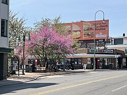
 Schauffele Plaza | |
| Motto: "The Main Street of the Main Line" | |
 Location in Delaware County and the U.S. state of Pennsylvania | |
| Coordinates: 40°00′24″N 75°17′07″W / 40.00667°N 75.28528°W | |
| Country | United States |
| State | Pennsylvania |
| Counties | Delaware, Montgomery |
| Townships | Haverford, Lower Merion |
| Area | |
• Total | 1.97 sq mi (5.09 km2) |
| • Land | 1.97 sq mi (5.09 km2) |
| • Water | 0.00 sq mi (0.00 km2) |
| Elevation | 282 ft (86 m) |
| Population | |
• Total | 13,566 |
| • Density | 6,900.31/sq mi (2,664.01/km2) |
| Time zone | UTC-5 (EST) |
| • Summer (DST) | UTC-4 (EDT) |
| ZIP Code | 19003 |
| Area codes | 610 and 484 |
| FIPS code | 42-02896 |
Ardmore is an unincorporated community and census-designated place (CDP) spanning the border between Delaware and Montgomery counties in the U.S. state of Pennsylvania. The population was 12,455 at the time of the 2010 census[3] and had risen to 13,566 in the 2020 census.[4]

Ardmore is a suburb on the west side of Philadelphia within Lower Merion Township in Montgomery County and Haverford Township in Delaware County.
- ^ "ArcGIS REST Services Directory". United States Census Bureau. Retrieved October 12, 2022.
- ^ Cite error: The named reference
USCensusDecennial2020CenPopScriptOnlywas invoked but never defined (see the help page). - ^ "Geographic Identifiers: 2010 Demographic Profile Data (G001): Ardmore CDP, Pennsylvania". U.S. Census Bureau, American Factfinder. Archived from the original on February 13, 2020. Retrieved December 30, 2015.
- ^ "Admore CDP, Pennsylvania". United States Census Bureau. Retrieved February 12, 2022.