Back أركاليك Arabic اركاليك ARZ Арҡалыҡ Bashkir Аркалък Bulgarian Arkalik Catalan Аркхаликх CE Arkalyk (lungsod) CEB ئارقالق CKB Arkalyk Czech Arqalyq German
This article needs additional citations for verification. (January 2019) |
Arkalyk
Arqalyq Арқалық | |
|---|---|
 | |
| Coordinates: 50°14′53″N 66°55′40″E / 50.24806°N 66.92778°E | |
| Country | Kazakhstan |
| Region | Kostanay Region |
| Government | |
| • Akim | Amirkhan Asanov |
| Population (2009) | |
• Total | 28,169 |
| Time zone | UTC+6 |
| Climate | Dfb |
| Website | http://www.arkalyk.kz/ |
 | |
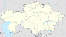
Arkalyk or Arqalyq (Kazakh: Арқалық, Arqalyq, pronounced [ɑɾqɑɫɯq] ⓘ; Russian: Аркалык) is a city in Kostanay Region, northern Kazakhstan. Earlier, it was the centre of Torgay Region, which was abolished in 1997. Established in 1956, it acquired the status of the city in 1965. The distance from the town of Arkalyk to Qostanai is 480 km (298 mi), to Astana is 670 km (416 mi). Population: 28,169 (2009 Census results);[1]45,736 (1999 Census results).[1]
The Arkalyk Business Centre describes today's Arkalyk as "a city of miners, of regional administrators, and people excited to live in a regional center". Historically Arkalyk was a centre for the Soviet space programme. Cosmonauts would land on the huge central Kazakh steppe and come back to Arkalyk before heading to the Baikonur, the Soviet Union's premier "space city". Arkalyk is served by Arkalyk Airport.
The city is linked by rail communication with the regional center (terminal station on a branch Esil - Derzhavinsk - Arkalyk). Roads Kostanay - Arkalyk tarmac, but is severely broken in the state. Roads Zhezkazgan - Arkalyk ground, in the wet weather becomes difficult even for freight transport because of mud. There is an airport (located 6 kilometers north-east of the city), capable of class aircraft Tu-154, Tu-134, etc. In Soviet times, it carried out flights to many cities in Kazakhstan, but since the mid-1990s an airport has been practically abandoned and used only sporadically during the search and rescue for the planting of crewed spaceaids.
- ^ a b "Население Республики Казахстан" [Population of the Republic of Kazakhstan] (in Russian). Департамент социальной и демографической статистики. Retrieved 8 December 2013.

