Back Arkansasrivier Afrikaans نهر أركنساس Arabic نهر اركنساس ARZ آرکانزاس چایی AZB Арканзас (рака) Byelorussian Арканзас (рака) BE-X-OLD Арканзас (река) Bulgarian আরকানসাস নদী Bengali/Bangla Arkansas (rijeka) BS Riu Arkansas Catalan
| Arkansas River | |
|---|---|
 Arkansas River headwaters in Colorado | |
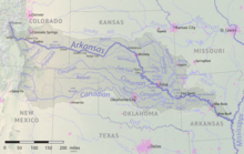
 The Arkansas River flows through Colorado, Kansas, Oklahoma, and Arkansas, and its watershed also drains parts of Texas, New Mexico and Missouri. | |
| Location | |
| Country | United States |
| State | Colorado, Kansas, Oklahoma, Arkansas |
| Region | Great Plains |
| Cities | Pueblo, CO, Wichita, KS, Tulsa, OK, Muskogee, OK, Fort Smith, AR, Little Rock, AR, Pine Bluff, AR |
| Physical characteristics | |
| Source | Confluence of East Fork Arkansas River and Tennessee Creek |
| • location | Near Leadville, Rocky Mountains, Colorado |
| • coordinates | 39°15′30″N 106°20′38″W / 39.25833°N 106.34389°W[1] |
| • elevation | 9,728 ft (2,965 m) |
| Mouth | Mississippi River |
• location | Franklin Township, Desha County, near Napoleon, Arkansas |
• coordinates | 33°46′30″N 91°6′30″W / 33.77500°N 91.10833°W[2][1] |
• elevation | 108 ft (33 m)[3][1] |
| Length | 1,469 mi (2,364 km), West-east[4] |
| Basin size | 168,000 sq mi (440,000 km2)[5] |
| Discharge | |
| • location | Little Rock, AR[6] |
| • average | 39,850 cu ft/s (1,128 m3/s)[6] |
| • minimum | 1,141 cu ft/s (32.3 m3/s) |
| • maximum | 536,000 cu ft/s (15,200 m3/s) |
| Basin features | |
| River system | Mississippi River watershed |
| Tributaries | |
| • left | Fountain Creek, Pawnee River, Little Arkansas River, Walnut River, Verdigris River, Neosho River |
| • right | Cimarron River, Salt Fork Arkansas River, La Flecha, Canadian River, Poteau River |
 | |
The Arkansas River is a major tributary of the Mississippi River. It generally flows to the east and southeast as it traverses the U.S. states of Colorado, Kansas, Oklahoma, and Arkansas. The river's source basin lies in Colorado, specifically the Arkansas River Valley. The headwaters derive from the snowpack in the Sawatch and Mosquito mountain ranges. It flows east into Kansas and finally through Oklahoma and Arkansas, where it meets the Mississippi River.
At 1,469 miles (2,364 km), it is the sixth-longest river in the United States,[7] the second-longest tributary in the Mississippi–Missouri system, and the 47th longest river in the world. Its origin is in the Rocky Mountains in Lake County, Colorado, near Leadville. In 1859, placer gold discovered in the Leadville area brought thousands seeking to strike it rich, but the easily recovered placer gold was quickly exhausted.[8] The Arkansas River's mouth is at Napoleon, Arkansas, and its drainage basin covers nearly 170,000 square miles (440,000 km2).[5] Its volume is much smaller than the Missouri and Ohio rivers, with a mean discharge of about 40,000 cubic feet per second (1,100 m3/s).
The Arkansas from its headwaters to the 100th meridian west formed part of the U.S.–Mexico border from the Adams–Onís Treaty (in force 1821) until the Texas Annexation or Treaty of Guadalupe Hidalgo.
- ^ a b c "Arkansas River". Geographic Names Information System. United States Geological Survey, United States Department of the Interior. April 30, 1980. Retrieved September 20, 2010.
- ^ The mouth has changed since plotting by USGS to Mississippi River Mile 580 from Mile 582 in the 1980 survey.
- ^ The mouth has changed since plotting by USGS.
- ^ a b See watershed maps: 1 Archived October 27, 2004, at the Wayback Machine
- ^ a b "USGS Gage #07263500 Arkansas River at Little Rock, AR". National Water Information System. U.S. Geological Survey. 1927–1970. Retrieved October 19, 2018.
- ^ J.C. Kammerer (May 1990). "Largest Rivers in the United States". United States Geological Survey. Archived from the original on March 21, 2007. Retrieved April 5, 2007.
{{cite journal}}: Cite journal requires|journal=(help) - ^ "Chaffee County Colorado Gold Production". Westernmininghistory.com. February 13, 2007. Retrieved November 15, 2012.