Back أرنولد (ماريلند) Arabic آرنولد، مریلند AZB Arnold (Maryland) Catalan Arnold (lungsod sa Tinipong Bansa, Maryland) CEB Arnold (Maryland) Spanish Arnold (Maryland) Basque آرنولد، مریلند Persian آرنولد (مريلند) GLK Arnold, Maryland ID Arnold (Maryland) Italian
Arnold, Maryland | |
|---|---|
 Baltimore-Annapolis Boulevard in Arnold | |
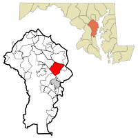
 Location of Arnold, Maryland | |
| Coordinates: 39°01′55″N 76°30′10″W / 39.03194°N 76.50278°W | |
| Country | |
| State | |
| County | |
| Area | |
• Total | 13.56 sq mi (35.11 km2) |
| • Land | 10.82 sq mi (28.02 km2) |
| • Water | 2.74 sq mi (7.09 km2) |
| Elevation | 128 ft (39 m) |
| Population (2020) | |
• Total | 24,064 |
| • Density | 2,224.24/sq mi (858.80/km2) |
| Time zone | UTC−5 (Eastern (EST)) |
| • Summer (DST) | UTC−4 (EDT) |
| ZIP code | 21012 |
| Area code | 410 |
| FIPS code | 24-02275 |
| GNIS feature ID | 582920[2] |
Arnold, a census-designated place (CDP) in Anne Arundel County, Maryland, United States, located just outside of the state's capital, Annapolis. It is located 18.78 miles south of Baltimore,[3] and 29.97 miles east of Washington, D.C.[4] The population was 23,106 at the 2010 census.[5] Neighborhoods straddle College Parkway and Maryland Route 2 (Ritchie Highway). Arnold is located on the scenic Broadneck Peninsula. The ZIP code is 21012. It is bordered by Severna Park to the northwest, Cape Saint Claire to the southeast, Annapolis to the southwest, and Lake Shore (a CDP within Pasadena) to the northeast.
- ^ "2020 U.S. Gazetteer Files". United States Census Bureau. Retrieved April 26, 2022.
- ^ "Arnold". Geographic Names Information System. United States Geological Survey, United States Department of the Interior. Retrieved August 21, 2023.
- ^ "Distance between Arnold, MD and Baltimore, MD".
- ^ "Distance between Arnold, MD and Washington, DC".
- ^ "Geographic Identifiers: 2010 Demographic Profile Data (G001): Arnold CDP, Maryland". U.S. Census Bureau, American Factfinder. Archived from the original on February 12, 2020. Retrieved May 29, 2013.