Back Districto de Sant Flor AN Sen-Flur (rayon) Azerbaijani Arrondissement Saint-Flour BAR Arondisamant Sant-Flor Breton Districte de Sant Flor Catalan Сен-ФлугӀ (гуо) CE Arrondissement de Saint-Flour CEB Arrondissement Saint-Flour Czech Arrondissement Saint-Flour German Arondismento Saint-Flour Esperanto
Saint-Flour | |
|---|---|
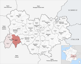
 Location within the region Auvergne-Rhône-Alpes | |
| Country | France |
| Region | Auvergne-Rhône-Alpes |
| Department | Cantal |
| No. of communes | 98 |
| Subprefecture | Saint-Flour |
Area | 2,510.6 km2 (969.3 sq mi) |
| Population (2022)[1] | 36,601 |
| • Density | 15/km2 (40/sq mi) |
| INSEE code | 153 |
The arrondissement of Saint-Flour is an arrondissement of France in the Cantal department in the Auvergne-Rhône-Alpes region. It has 98 communes.[2] Its population is 36,904 (2021), and its area is 2,510.6 km2 (969.3 sq mi).[3]
- ^ "Populations de référence 2022" (in French). The National Institute of Statistics and Economic Studies. 19 December 2024.
- ^ Cite error: The named reference
insee2was invoked but never defined (see the help page). - ^ "Comparateur de territoire, géographie au 01/01/2023". INSEE. Retrieved 9 December 2024.