Back Ascension (eiland) Afrikaans Ascension ALS Isla Ascensión AN Upstigeieg ANG असेंशियन द्वीप ANP جزيرة أسينشين Arabic جزيرة اسينشين ARZ Islla Ascensión AST Yüksəliş adası Azerbaijani Олғашыу Утрауы Bashkir
Ascension Island | |
|---|---|
| Anthem: "God Save the King" | |
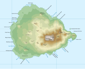
 Topographic map of Ascension Island | |
 Location of Ascension Island in the southern Atlantic Ocean | |
| Sovereign state | |
| British settlement | 1815 |
| Dependency of Saint Helena | 12 September 1922 |
| Current constitution | 1 September 2009 |
| Capital and largest settlement | Georgetown 7°56′S 14°25′W / 7.933°S 14.417°W |
| Official languages | English |
| Government | Devolved locally governing dependency under a constitutional monarchy |
• Monarch | Charles III |
• Governor | Nigel Phillips |
| Simon Minshull[1] | |
| Legislature | Island Council |
| National representation | |
• Minister | Stephen Doughty |
| Area | |
• Total | 88 km2 (34 sq mi) |
| Highest elevation | 859 m (2,818 ft) |
| Population | |
• 2016 census | 806[2] |
• Density | 9.15/km2 (23.7/sq mi) |
| Currency | Saint Helena pound (£) (SHP) |
| Time zone | UTC±00:00 (GMT) |
| Date format | dd/mm/yyyy |
| Driving side | Left |
| Calling code | +247 |
| UK postcode | ASCN 1ZZ |
| ISO 3166 code | SH-AC |
| Internet TLD | .ac |
Ascension Island is an isolated volcanic island, 7°56′ south of the Equator in the South Atlantic Ocean. It is about 960 miles (1,540 km) from the coast of Africa and 1,400 miles (2,300 km) from the coast of South America. It is governed as part of the British Overseas Territory of Saint Helena, Ascension and Tristan da Cunha,[3] of which the main island, Saint Helena, is around 800 miles (1,300 km) to the southeast. The territory also includes the sparsely populated Tristan da Cunha archipelago, 2,000 miles (3,200 km) to the south, about halfway to the Antarctic Circle.
The discovery of Ascension by Joao da Nova in 1501 was described by two Portuguese chroniclers who probably misnamed it as Conception Island. The popular idea that Ascension was rediscovered by Afonso de Albuquerque in 1503 is probably wrong, Ascension having been long confused with Trindade. Ascension Island was garrisoned by the British Admiralty from 22 October 1815 to 1922 and was an important refueling stop for ships and commercial airliners in the days of international air travel by flying boats. During World War II, it was an important naval and air station, especially providing antisubmarine warfare bases in the Battle of the Atlantic.[4]
The island is the location of RAF Ascension Island, which is a Royal Air Force station, a European Space Agency rocket tracking station, a British-American signals intelligence facility and the BBC World Service Atlantic Relay Station. The island was used extensively as a staging point by the British military during the Falklands War. Ascension Island hosts one of four ground antennas that assist in the operation of the Global Positioning System (GPS) navigational system (the others are on Kwajalein Island, Diego Garcia, and Cape Canaveral). NASA operates a Meter Class Autonomous Telescope (MCAT) on Ascension Island for tracking orbital debris, which is potentially hazardous to operating spacecraft and astronauts, at a facility called the John Africano NASA/AFRL Orbital Debris Observatory.[5]
- ^ "The Administrator – Ascension Island Government".
- ^ "Census 2016 – summary report" (PDF). St Helena Government. June 2016. p. 9. Archived (PDF) from the original on 17 October 2016. Retrieved 23 January 2017.
- ^ "The St Helena, Ascension and Tristan da Cunha Constitution Order 2009". Archived from the original on 12 March 2010. Retrieved 26 September 2009.
- ^ Victory at Sea (Series title), Volume-10 "Beneath the Southern Cross" 1952 production of NBC, (Disc 2 of DVD collection reproduction ca. 2007–08)
- ^ Garcia, Mark (11 August 2016). "Searching for "Space Junk" in Paradise". Archived from the original on 15 August 2016. Retrieved 14 August 2016.

