Back Ashfield (bahin nga lungsod) CEB اشفیلد، نیو ساوت ولز Persian Ashfield (Nouvelle-Galles du Sud) French Ashfield (Nuovo Galles del Sud) Italian Ashfield (New South Wales) Dutch Ashfield (Nova Gales do Sul) Portuguese Ashfield, New South Wales Romanian Ashfield, New South Wales SIMPLE Ashfield, New South Wales Swedish ایش فیلڈ، نیوساؤتھ ویلز Urdu
| Ashfield Sydney, New South Wales | |||||||||||||||
|---|---|---|---|---|---|---|---|---|---|---|---|---|---|---|---|
 | |||||||||||||||
 | |||||||||||||||
| Population | 23,012 (2021 census)[1] | ||||||||||||||
| • Density | 6,748/km2 (17,478/sq mi) | ||||||||||||||
| Established | 1838 | ||||||||||||||
| Postcode(s) | 2131 | ||||||||||||||
| Elevation | 34 m (112 ft) | ||||||||||||||
| Area | 3.41 km2 (1.3 sq mi) | ||||||||||||||
| Location | 8 km (5 mi) west of Sydney central business district | ||||||||||||||
| LGA(s) | Inner West Council | ||||||||||||||
| State electorate(s) | |||||||||||||||
| Federal division(s) | |||||||||||||||
| |||||||||||||||

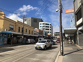
Ashfield is a suburb in the Inner West[3] of Sydney, in the state of New South Wales, Australia. Ashfield is about 8 kilometres west of the Sydney central business district.
Ashfield's population is highly multicultural with the majority of the area's dwellings being a mixture of mainly post-war low-rise flats (apartment blocks) and Federation-era detached houses. Amongst these are a number of grand Victorian buildings that offer a hint of Ashfield's rich cultural heritage.
- ^ Australian Bureau of Statistics (28 June 2022). "Ashfield (NSW)". 2021 Census QuickStats. Retrieved 12 November 2024.
- ^ Horsburgh, Richard. "Comment to Facebook post '#ChinOzHistoryinOldSydneyAlbum - #1 in a series*** --- QUONG TART PART 1 '". Facebook.
- ^ Australian Suburb Guide: Sydney Inner West Archived 26 December 2012 at the Wayback Machine Retrieved 7 August 2013.