Back مقاطعة آشلاند (ويسكونسن) Arabic Ashland County, Wisconsin BAR Ашланд (окръг, Уисконсин) Bulgarian অ্যাসল্যান্ড কাউন্টি, উইসকনসিন BPY Ashland Gông (Wisconsin) CDO Ашленд (гуо, Висконсин) CE Ashland County (kondado sa Tinipong Bansa, Wisconsin) CEB Ashland County, Wisconsin Welsh Ashland County (Wisconsin) German Kantono Ashland (Viskonsino) Esperanto
Ashland County | |
|---|---|
 | |
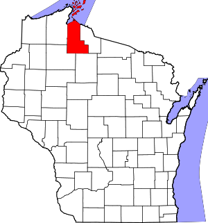
 Location within the U.S. state of Wisconsin | |
 Wisconsin's location within the U.S. | |
| Coordinates: 46°43′N 90°34′W / 46.71°N 90.56°W | |
| Country | |
| State | |
| Founded | March 27, 1860 |
| Named for | Henry Clay's farm Ashland |
| Seat | Ashland |
| Largest city | Ashland |
| Area | |
• Total | 2,292 sq mi (5,940 km2) |
| • Land | 1,045 sq mi (2,710 km2) |
| • Water | 1,247 sq mi (3,230 km2) 54% |
| Population | |
• Total | 16,027 |
• Estimate (2023) | 16,079 |
| • Density | 15.3/sq mi (5.9/km2) |
| Time zone | UTC−6 (Central) |
| • Summer (DST) | UTC−5 (CDT) |
| Congressional district | 7th |
| Website | www |
Ashland County is a county located in the U.S. state of Wisconsin. As of the 2020 census, the population was 16,027.[1] Its county seat is Ashland.[2] The county was formed on March 27, 1860, from La Pointe County.[3] The county partly overlaps with the reservation of the Bad River Band of the Lake Superior Tribe of Chippewa Indians.
- ^ a b Cite error: The named reference
2020-census-55003was invoked but never defined (see the help page). - ^ "Find a County". National Association of Counties. Archived from the original on May 31, 2011. Retrieved June 7, 2011.
- ^ "Wisconsin History: La Pointe County (obsolete)". Archived from the original on June 11, 2011. Retrieved September 20, 2008.