Back أثرتون (كاليفورنيا) Arabic اثرتون (كاليفورنيا) ARZ آترتون، کالیفورنیا AZB Адъртън Bulgarian Atherton (Califòrnia) Catalan Атертон (Калифорни) CE Atherton (lungsod sa Tinipong Bansa) CEB Atherton (Kalifornie) Czech Atherton (Kalifornien) German Atherton (California) Spanish
Atherton, California | |
|---|---|
| Town of Atherton | |
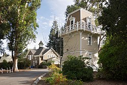
 Holbrook-Palmer Park | |
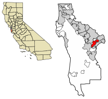
 Location of Atherton in San Mateo County, California | |
| Coordinates: 37°27′31″N 122°12′0″W / 37.45861°N 122.20000°W[1] | |
| Country | United States |
| State | California |
| County | San Mateo |
| Incorporated | September 12, 1923[2] |
| Named for | Faxon Dean Atherton[2] |
| Government | |
| • City council[5] |
|
| • Assemblymember | Alex Lee (D) (24th)[3] |
| • State Senator | Josh Becker (D) (13th)[3] |
| • U.S. Rep. | Sam Liccardo (D) (16th)[4] |
| Area | |
• Total | 5.05 sq mi (13.07 km2) |
| • Land | 5.02 sq mi (12.99 km2) |
| • Water | 0.03 sq mi (0.08 km2) 0.63% |
| Elevation | 59 ft (18 m) |
| Population (2020) | |
• Total | 7,188 |
| • Density | 1,433.01/sq mi (553.28/km2) |
| Time zone | UTC−8 (Pacific) |
| • Summer (DST) | UTC−7 (PDT) |
| ZIP Code[7] | 94027 |
| Area code[8] | 650 |
| FIPS code | 06-03092 |
| GNIS feature IDs | 1657960, 2411651 |
| Website | www |
Atherton (/ˈæθərtən/ ATH-ər-tən) is an incorporated town in San Mateo County, California, United States. Its population was 6,823 as of July 2023 estimates. The town's zoning regulations permit only one single-family home per acre, and prohibit sidewalks.[9]
Atherton is known for its high concentration of wealth; in 1990 and 2019,[10] Atherton was ranked as having the highest per capita income among U.S. places that have a population between 2,500 and 9,999,[11] and the area covered by its ZIP Code is regularly ranked as having the highest cost of living in the United States.[12][13][14][15] In 2023, the Atherton ZIP Code had the highest median home prices in the United States, at $7,950,000.[16]
- ^ a b "Atherton". Geographic Names Information System. United States Geological Survey, United States Department of the Interior. Retrieved August 21, 2009.
- ^ a b "Atherton History". Town of Atherton. April 27, 2007. Archived from the original on September 12, 2009. Retrieved August 21, 2009.
- ^ a b "Statewide Database". UC Regents. Archived from the original on February 1, 2015. Retrieved December 29, 2014.
- ^ "California's 16th Congressional District - Representatives & District Map". Civic Impulse, LLC. Retrieved March 13, 2013.
- ^ "City Council". Town of Atherton. Retrieved December 29, 2014.
- ^ "2020 U.S. Gazetteer Files". United States Census Bureau. Retrieved October 30, 2021.
- ^ "USPS – ZIP Code Lookup – Search By City". United States Postal Service. Archived from the original on August 30, 2009. Retrieved August 21, 2009.
- ^ "NANP Administration System". North American Numbering Plan Administration. Archived from the original on September 22, 2010. Retrieved August 21, 2009.
- ^ Cite error: The named reference
Griffithwas invoked but never defined (see the help page). - ^ "These Are the Wealthiest Towns in the U.S." Bloomberg. Retrieved August 18, 2018.
- ^ Archive of "1990 CPH-L-126. Median Family Income for Places with a Population of 2,500 to 9,999, Ranked Within the United States: 1989", United States Census Bureau. 1990 CPH-L-126F.html Original page
- ^ Levy, Francesca (September 27, 2010). "America's Most Expensive ZIP Codes". Forbes.
- ^ Brennan, Morgan (October 16, 2013). "America's Most Expensive Zip Codes In 2013: The Complete List". Forbes. Archived from the original on October 19, 2013.
- ^ Sharf, Samantha (December 8, 2016). "Full List: America's Most Expensive ZIP Codes 2016". Forbes. Retrieved August 24, 2017.
- ^ SFGATE, Sam Moore (November 22, 2022). "Bay Area town named most expensive ZIP code for 6th year". SFGATE.
- ^ Kolomatsky, Michael (November 9, 2023). "America's Most Expensive ZIP Codes". The New York Times. Retrieved November 9, 2023.


