Back Eostrabyrg ANG أورورا (كولورادو) Arabic اورورا (اراباهو) ARZ Aurora Azerbaijani آورورا کولورادو AZB Арора (Каларада) Byelorussian Аўрора (Каларада) BE-X-OLD Аурора (Колорадо) Bulgarian Aurora (Colorado) Breton Aurora (Colorado) Catalan
Aurora | |
|---|---|
 The Southlands, an Aurora-based shopping mall | |
| Nicknames: The Gateway to the Rockies The Sunrise of Colorado | |
 | |
| Coordinates: 39°43′46″N 104°49′55″W / 39.7294°N 104.8319°W[3] | |
| Country | United States |
| State | Colorado |
| County | Arapahoe County[2] Adams County Douglas County |
| Platted | 1891 as Fletcher, Colorado |
| Incorporated (town) | May 5, 1903, as the Town of Fletcher[4] |
| Incorporated (city) | March 9, 1928 as the City of Aurora[5] |
| Government | |
| • Type | Home Rule City[1] |
| • Mayor | Mike Coffman (R) (Since December 2, 2019)[citation needed] |
| • City Manager | Jason Batchelor[citation needed] |
| Area | |
• Total | 163.588 sq mi (423.691 km2) |
| • Land | 163.009 sq mi (422.191 km2) |
| • Water | 0.579 sq mi (1.500 km2) |
| • Rank | 2nd in Colorado 54th in the United States |
| Elevation | 5,404 ft (1,647 m) |
| Population | |
• Total | 386,261 |
| • Rank | 3rd in Colorado 52nd in the United States |
| • Density | 2,412/sq mi (931/km2) |
| Demonyms | Auroran |
| Time zone | UTC−07:00 (MST) |
| • Summer (DST) | UTC−06:00 (MDT) |
| ZIP Codes | |
| Area codes | Both 303 and 720 |
| GNIS pop ID | 204737 |
| GNIS city ID | 2409757 |
| FIPS code | 08-04000 |
| Website | City of Aurora |
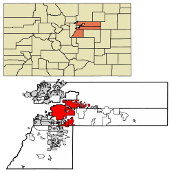
Aurora (/əˈroʊrə/, /əˈrɔːrə/) is a Home Rule City located in Arapahoe, Adams, and Douglas counties, Colorado, United States.[1] The city's population was 386,261 at the 2020 United States Census with 336,035 residing in Arapahoe County, 47,720 residing in Adams County, and 2,506 residing in Douglas County.[7] Aurora is the third-most-populous city in the State of Colorado and the 52nd-most-populous city in the United States. Aurora is a principal city of the Denver–Aurora–Lakewood Metropolitan Statistical Area (MSA) and a major city of the Front Range Urban Corridor.
- ^ a b c "Active Colorado Municipalities". Colorado Department of Local Affairs. Retrieved January 20, 2025.
- ^ "Colorado Counties". Colorado Department of Local Affairs. Retrieved January 20, 2025.
- ^ a b "Aurora, Colorado". Geographic Names Information System. United States Geological Survey, United States Department of the Interior. Retrieved January 20, 2025.
- ^ "Colorado Municipal Incorporations". State of Colorado, Department of Personnel & Administration, Colorado State Archives. December 1, 2004. Archived from the original on September 27, 2007. Retrieved August 18, 2007.
- ^ "Official Notice of City in this Issue". The Aurora Democrat. Vol. 19, no. 12. March 9, 1928. p. 1.
- ^ Cite error: The named reference
Gazetteer Fileswas invoked but never defined (see the help page). - ^ a b "Decennial Census P.L. 94-171 Redistricting Data". United States Census Bureau, United States Department of Commerce. August 12, 2021. Retrieved September 2, 2021.
- ^ "ZIP Code Lookup". United States Postal Service. August 19, 2007. Archived from the original (JavaScript/HTML) on August 18, 2007. Retrieved August 19, 2007. The post office serving 80137 is located in Aurora, but "Watkins" is the place nameCity assigned to the ZIP code.


