Austin | |
|---|---|
| Community Area 25 – Austin | |
 The Austin Town Hall Park field house. | |
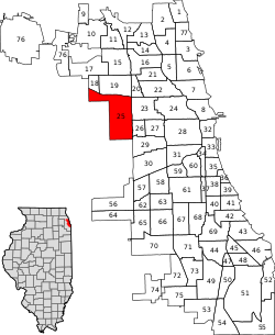
 Location within the city of Chicago | |
| Coordinates: 41°54′N 87°45.6′W / 41.900°N 87.7600°W | |
| Country | United States |
| State | Illinois |
| County | Cook |
| City | Chicago |
| Neighborhoods | |
| Area | |
• Total | 7.16 sq mi (18.54 km2) |
| Population (2020)[1] | |
• Total | 100,120 |
| • Density | 14,000/sq mi (5,400/km2) |
| Demographics (2022)[1] | |
| • White | 5.4% |
| • Black | 72.8% |
| • Hispanic | 19.4% |
| • Asian | 0.6% |
| • Other | 1.7% |
| Educational Attainment 2022[1] | |
| • High School Diploma or Higher | 82.3% |
| • Bachelor's Degree or Higher | 14.5% |
| Time zone | UTC-6 (CST) |
| • Summer (DST) | UTC-5 (CDT) |
| ZIP Codes | 60644 (entire) 60639, 60651, 60707 (partial) |
| Median household income (2022)[1] | $40,086 |
Austin is one of 77 community areas in Chicago. Located on the city's West Side, it is the third-largest community area by population (behind the Near North Side and Lake View) and the second-largest geographically (behind South Deering). Austin's eastern boundary is the Belt Railway located just east of Cicero Avenue. Its northernmost border is the Milwaukee District / West Line. Its southernmost border is at Roosevelt Road from the Belt Railway west to Austin Boulevard. The northernmost portion, north of North Avenue, extends west to Harlem Avenue, abutting Elmwood Park. In addition to Elmwood Park, Austin also borders the suburbs of Cicero and Oak Park.[2]
- ^ a b c d "Community Demographic Snapshot: Austin" (PDF). Chicago Metropolitan Agency for Planning. June 2020. Retrieved February 28, 2023.
- ^ Zangs, Mary (July 1, 2014). The Chicago 77: A Community Area Handbook. Stroud, Gloucestershire, England: The History Press. ISBN 978-1626196124.
