| Bald Eagle State Forest | |
|---|---|
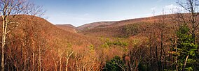
 Bald Eagle State Forest vista from Pine Swamp Road in Centre County | |
Location of Bald Eagle State Forest's headquarters in Pennsylvania | |
| Location | Pennsylvania, U.S. |
| Coordinates | 40°53′16″N 77°39′22″W / 40.88778°N 77.65611°W |
| Area | 194,602 acres (787.53 km2) |
| Elevation | 1,788 ft (545 m) |
| Governing body | Pennsylvania Department of Conservation and Natural Resources |
| Website | https://www.dcnr.pa.gov/StateForests/FindAForest/BaldEagle/Pages/default.aspx |
Bald Eagle State Forest is a Pennsylvania state forest in Pennsylvania Bureau of Forestry District #7. The main office is located in Laurelton in Union County, Pennsylvania. The forest is found in Centre, Clinton, Mifflin, Snyder, and Union Counties. Bald Eagle shares a common border on its western extent with Rothrock State Forest and on its northern extent with Tiadaghton State Forest.
Five Pennsylvania State Parks are contained within the forest: Poe Valley, Poe Paddy, R. B. Winter, Reeds Gap, and Sand Bridge, as well as two former state parks: Snyder-Middleswarth Natural Area (formerly Snyder-Middleswarth State Park) and Hairy Johns Picnic Area (formerly a state park known as both "Hairy John's State Forest Park" and "Voneida State Forest Park").

