Back আম্ফোয়ে বান তা খুন BPY Amphoe Ban Takhun CEB Amphoe Ban Ta Khun German Distretto di Ban Ta Khun Italian バーンタークン郡 Japanese 반따쿤군 Korean Ban Ta Khun Portuguese Districtul Ban Ta Khun Romanian อำเภอบ้านตาขุน Thai Ban Ta Khun (huyện) Vietnamese
Ban Ta Khun
บ้านตาขุน | |
|---|---|
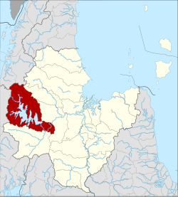
 District location in Surat Thani province | |
| Coordinates: 8°54′18″N 98°53′6″E / 8.90500°N 98.88500°E | |
| Country | Thailand |
| Province | Surat Thani |
| Seat | Khao Wong |
| Area | |
• Total | 1,308.2 km2 (505.1 sq mi) |
| Population (2005) | |
• Total | 14,116 |
| • Density | 10.8/km2 (28/sq mi) |
| Time zone | UTC+7 (ICT) |
| Postal code | 84230 |
| Geocode | 8409 |
Ban Ta Khun (Thai: บ้านตาขุน, pronounced [bâːn tāː kʰǔn]) is an amphoe in western Surat Thani province, southern Thailand. It is the largest district of the province and has the lowest population density.