Back باتيسكون (كيبك) Arabic Batiscan CEB Batiscan (Quebec) Basque باتیسکان، کبک Persian Batiscan French Batiscan Italian Batiscan Swedish
Batiscan | |
|---|---|
 | |
| Motto: "Do Well What You Do" | |
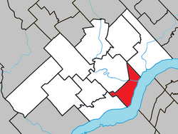
 Location within Les Chenaux RCM | |
| Coordinates: 46°30′N 72°15′W / 46.500°N 72.250°W[1] | |
| Country | |
| Province | |
| Region | Mauricie |
| RCM | Les Chenaux |
| Settled | 1666 |
| Constituted | July 1, 1855 |
| Government | |
| • Mayor | Christian Fortin |
| • Federal riding | Saint-Maurice—Champlain |
| • Prov. riding | Champlain |
| Area | |
• Total | 58.74 km2 (22.68 sq mi) |
| • Land | 43.23 km2 (16.69 sq mi) |
| Population (2021)[3] | |
• Total | 958 |
| • Density | 22.2/km2 (57/sq mi) |
| • Pop (2016-21) | |
| • Dwellings | 545 |
| Time zone | UTC−5 (EST) |
| • Summer (DST) | UTC−4 (EDT) |
| Postal code(s) | |
| Area codes | 418 and 581 |
| Highways | |
| GNBC Code | ELIDL |
| NTS Map | 031I08 |
| Website | batiscan |
Batiscan (French pronunciation: [batiskɑ̃]) is a municipality in the Mauricie region of the province of Quebec in Canada. It is located along the St Lawrence River at the mouth of the Batiscan River.
The usage includes Batiscan in Batiscanie, the common name for the region.[4]
- ^ Cite error: The named reference
toponymiewas invoked but never defined (see the help page). - ^ a b Cite error: The named reference
mamrotwas invoked but never defined (see the help page). - ^ a b Cite error: The named reference
SCref21was invoked but never defined (see the help page). - ^ Cite error: The named reference
Colonization of the Batiscan Lordshipwas invoked but never defined (see the help page).
