Back Propinsi Batken ACE مقاطعة باتكين Arabic Batken vilayəti Azerbaijani Баткенская вобласць Byelorussian Баткенская вобласьць BE-X-OLD Баткенска област Bulgarian Província de Batkén Catalan Баткенан область CE Batken (lalawigan) CEB Batkenská oblast Czech
Batken Region
| |
|---|---|
Region | |
Road and field in Batken | |
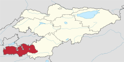
 Map of Kyrgyzstan, location of Batken Region highlighted | |
| Coordinates: 39°50′N 71°30′E / 39.833°N 71.500°E | |
| Country | |
| Capital | Batken |
| Government | |
| • Governor | Mamat Aibalayev |
| Area | |
• Total | 17,048 km2 (6,582 sq mi) |
| Population (2023-01-01)[1] | |
• Total | 570,898 |
| • Density | 33/km2 (87/sq mi) |
| Time zone | UTC+6 (Kyrgyzstan Time) |
| ISO 3166 code | KG-B |
| Districts | 3 |
| Cities | 6 |
| Towns | 1 |
| Villages | 198 |
Batken Region[a] is a region of Kyrgyzstan. Its capital is Batken. It is bounded on the east by Osh Region, on the south, west and north by Tajikistan, and on the northeast by Uzbekistan. The northern part of the region is part of the flat, agricultural Ferghana Valley. The land rises southward to the mountains on the southern border: the Alay Mountains in the east, and the Turkestan Range in the west. Its total area is 17,048 km2 (6,582 sq mi).[2] The resident population of the region was 548,247 as of January 2021.[1] The region has sizeable Uzbek (14.7% in 2009) and Tajik (6.9% in 2009) minorities.[2]
- ^ a b "Population of regions, districts, towns, urban-type settlements, rural communities and villages of Kyrgyz Republic" (XLS) (in Russian). National Statistics Committee of the Kyrgyz Republic. 2021. Archived from the original on 10 November 2021.
- ^ a b "2009 population and housing census of the Kyrgyz Republic: Batken Region" (PDF) (in Russian). National Statistics Committee of the Kyrgyz Republic. 2010. pp. 14, 17, 48, 185.
Cite error: There are <ref group=lower-alpha> tags or {{efn}} templates on this page, but the references will not show without a {{reflist|group=lower-alpha}} template or {{notelist}} template (see the help page).


