Back Baumschulenweg CEB Berlin-Baumschulenweg German باومشولنوگ Persian Berlin-Baumschulenweg French Baumschulenweg ID Baumschulenweg Italian Berlin-Baumschulenweg Dutch Baumschulenweg NB Baumschulenweg Polish Baumschulenweg Swedish
Baumschulenweg | |
|---|---|
 Panorama of the church "Zum Vaterhaus" | |
| Coordinates: 52°27′54″N 13°29′10″E / 52.46500°N 13.48611°E | |
| Country | Germany |
| State | Berlin |
| City | Berlin |
| Borough | Treptow-Köpenick |
| Founded | 1823 |
| Subdivisions | 1 zone |
| Area | |
• Total | 4.82 km2 (1.86 sq mi) |
| Elevation | 34 m (112 ft) |
| Population (2023-12-31)[1] | |
• Total | 19,258 |
| • Density | 4,000/km2 (10,000/sq mi) |
| Time zone | UTC+01:00 (CET) |
| • Summer (DST) | UTC+02:00 (CEST) |
| Postal codes | 12437 |
| Vehicle registration | B |
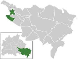
Baumschulenweg (German pronunciation: [ˈbaʊ̯mʃuːlənˌveːk] ⓘ) is a German locality (Ortsteil) within the Berlin borough (Bezirk) of Treptow-Köpenick. Until 2001 it was part of the former borough of Treptow. Its name means road (weg) of the plant nurseries (Baumschulen). It was named after the Späth nursery.


