Bedford Park | |
|---|---|
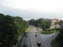
 View of the Mosholu Parkway in Bedford Park | |
 Location in New York City | |
| Coordinates: 40°52′12″N 73°53′10″W / 40.870°N 73.886°W | |
| Country | |
| State | |
| City | New York City |
| Borough | Bronx |
| Community District | Bronx 7[1] |
| Area | |
• Total | 1.18 km2 (0.455 sq mi) |
| Population (2011)[2] | |
• Total | 37,344 |
| • Density | 32,000/km2 (82,000/sq mi) |
| Economics | |
| • Median income | $43,850 |
| ZIP Codes | 10458, 10468 |
| Area code | 718, 347, 929, and 917 |
| Website | bedfordpark |
Bedford Park is a residential neighborhood in the northwest Bronx, New York City, adjacent to the New York Botanical Garden. Its boundaries, starting from the north and moving clockwise, are: Mosholu Parkway to the north, Webster Avenue to the east, East 196th Street to the south, and Jerome Avenue to the west.
The neighborhood is part of Bronx Community District 7, and its ZIP Codes include 10458 and 10468.[1] The area is patrolled by the 52nd Precinct of the New York City Police Department.
- ^ a b "NYC Planning | Community Profiles". communityprofiles.planning.nyc.gov. New York City Department of City Planning. Retrieved March 3, 2018.
- ^ a b "Bedford Park neighborhood in New York". Retrieved November 2, 2015.
