Back بند، کالیفورنیا AZB Бенд (Калифорни) CE Bend (lungsod) CEB Bend (California) Spanish Bend (Kalifornia) Basque بند، کالیفرنیا Persian Bend (Californie) French بند (کاليفؤرنيا) GLK Bend (Kalifornija) Croatian Bend (California) Italian
Bend | |
|---|---|
 A photograph of the Sacramento River as it passes through Bend, California. | |
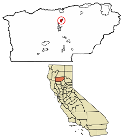
 Location of Bend in Tehama County, California. | |
| Coordinates: 40°15′19″N 122°12′31″W / 40.25528°N 122.20861°W | |
| Country | |
| State | |
| County | Tehama |
| Area | |
• Total | 3.17 sq mi (8.21 km2) |
| • Land | 2.91 sq mi (7.55 km2) |
| • Water | 0.26 sq mi (0.66 km2) 8.07% |
| Elevation | 335 ft (102 m) |
| Population (2020) | |
• Total | 603 |
| • Density | 206.93/sq mi (79.89/km2) |
| Time zone | UTC-8 (Pacific (PST)) |
| • Summer (DST) | UTC-7 (PDT) |
| ZIP code | 96080 |
| Area code | 530 |
| GNIS feature IDs | 1658034 |
| U.S. Geological Survey Geographic Names Information System: Bend, California | |
Bend is a census-designated place in Tehama County, California, United States. Bend is located on the Sacramento River 6 miles (9.7 km) north-northeast of Red Bluff. Bend had a post office from 1897 to 1935. The community was originally known as Horsethief Bend; the name was changed to Sander's Bend and later shortened to Bend.[3] The community was named after a nearby meander in the Sacramento River.[4] The population was 619 at the 2010 census.

- ^ "2020 U.S. Gazetteer Files". United States Census Bureau. Retrieved October 30, 2021.
- ^ U.S. Geological Survey Geographic Names Information System: Bend, California
- ^ Durham, David L. (1998). California's Geographic Names: A Gazetteer of Historic and Modern Names of the State. Clovis, Calif.: Word Dancer Press. p. 193. ISBN 1-884995-14-4.
- ^ "Place Names" (PDF). Archived from the original (PDF) on May 8, 2017. Retrieved March 25, 2018.
