Back مقاطعة بينتون (أوريغون) Arabic Benton County, Oregon BAR Бентън (окръг, Орегон) Bulgarian বেন্টন কাউন্টি, অরেগন BPY Benton Gông (Oregon) CDO Бентон (гуо, Орегон) CE Benton County (kondado sa Tinipong Bansa, Oregon) CEB Benton County (Oregon) Czech Benton County, Oregon Welsh Benton County (Oregon) German
Benton County | |
|---|---|
 Benton County Courthouse in Corvallis | |
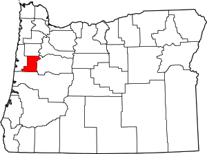
 Location within the U.S. state of Oregon | |
 Oregon's location within the U.S. | |
| Coordinates: 44°29′25″N 123°25′57″W / 44.490277777778°N 123.4325°W | |
| Country | |
| State | |
| Founded | December 23, 1847 |
| Named for | Thomas H. Benton |
| Seat | Corvallis |
| Largest city | Corvallis |
| Area | |
• Total | 679 sq mi (1,760 km2) |
| • Land | 676 sq mi (1,750 km2) |
| • Water | 2.7 sq mi (7 km2) 0.4% |
| Population (2020) | |
• Total | 95,184 |
• Estimate (2023) | 99,355 |
| • Density | 127/sq mi (49/km2) |
| Time zone | UTC−8 (Pacific) |
| • Summer (DST) | UTC−7 (PDT) |
| Congressional district | 4th |
| Website | www |

Benton County is one of the 36 counties in the U.S. state of Oregon. As of the 2023 census population estimates, the population was 99,355.[1] Its county seat is Corvallis.[2] The county was named after Thomas Hart Benton, a U.S. Senator who advocated American control over the Oregon Country. Benton County is designated as the Corvallis, OR Metropolitan Statistical Area, which is included in the Portland–Vancouver–Salem, OR–WA Combined Statistical Area. It is in the Willamette Valley.
- ^ "State & County QuickFacts". United States Census Bureau. Retrieved May 15, 2023.
- ^ "Find a County". National Association of Counties. Archived from the original on May 31, 2011. Retrieved June 7, 2011.