Back سلسلة بيرنينا Arabic Берніна (горны масіў) Byelorussian Бернина (масив) Bulgarian Massís de la Bernina Catalan Bernina (kabukiran sa Nasod nga Swiss) CEB Bernina Czech Bernina Alperne Danish Berninagruppe German Bernina Montaro Esperanto Macizo de la Bernina Spanish
| Bernina Range | |
|---|---|
 The main summits of the Bernina range above the Morteratsch Glacier | |
| Highest point | |
| Peak | Piz Bernina |
| Elevation | 4,049 m (13,284 ft)[1] |
| Listing | Mountain ranges |
| Coordinates | 46°37′N 09°52′E / 46.617°N 9.867°E |
| Geography | |
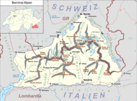
 Location of the Bernina Alps The borders of the range according to Alpine Club classification of the Eastern Alps | |
| Countries |
|
| Range coordinates | 46°22.8′N 9°54.6′E / 46.3800°N 9.9100°E |
| Parent range | Western Limestone Alps |
| Borders on | |
The Bernina Range is a mountain range in the Alps of eastern Switzerland and northern Italy. It is considered to be part of the Rhaetian Alps within the Central Eastern Alps. It is one of the highest ranges of the Alps, covered with many glaciers. Piz Bernina (4,049 m (13,284 ft)), its highest peak, is the most easterly four-thousand-metre peak in the Alps. The peak in the range which sees the most ascents is Piz Palü.
The Bernina Range is separated from the Albula Range in the north-west by the Maloja Pass and the Upper Engadin valley; from the Livigno Range in the east by the Bernina Pass; from the Bergamo Alps in the south by the Adda valley (Valtellina); and from the Bregaglia Range in the south-west by the Muretto Pass. The Bernina Range is drained by the rivers Adda, Inn and Maira (Mera in Italy).
The term Bernina Alps can also be used in an extended sense to include both the Bernina and Bregaglia ranges; this is the area coloured red on the map (right) and labelled 'Bernina Alpen'.
- ^ "Topographic map of Piz Bernina". opentopomap.org. Retrieved 3 July 2023.