Back بيت لحم (كونيتيكت) Arabic Bethlehem (Connecticut) Catalan Бетлегем (Коннектикут) CE Bethlehem, Connecticut Welsh Bethlehem (Connecticut) Spanish Bethlehem (Connecticut) Basque Bethlehem (Connecticut) French Bethlehem, Connecticut HT Bethlehem (Connecticut) Italian Безлехем (Коннектикут) Kazakh
Bethlehem, Connecticut | |
|---|---|
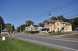
 Main Street South, Bethlehem Green Historic District | |
| Coordinates: 41°38′21″N 73°12′31″W / 41.63917°N 73.20861°W | |
| Country | |
| U.S. state | |
| County | Litchfield |
| Region | Naugatuck Valley |
| Incorporated | 1787 |
| Government | |
| • Type | Selectman-town meeting |
| • First selectman | Stephen F. Sordi (R) |
| • Selectman | George J. Rehkamp (R) |
| • Selectman | Raymond Butkus (D) |
| Area | |
• Total | 19.7 sq mi (50.9 km2) |
| • Land | 19.4 sq mi (50.2 km2) |
| • Water | 0.3 sq mi (0.7 km2) |
| Elevation | 860 ft (262 m) |
| Population (2020)[1] | |
• Total | 3,385 |
| • Density | 190/sq mi (72/km2) |
| Time zone | UTC-5 (Eastern) |
| • Summer (DST) | UTC-4 (Eastern) |
| ZIP code | 06751 |
| Area codes | 203/475 |
| FIPS code | 09-04930 |
| GNIS feature ID | 0213391 |
| Website | www |
Bethlehem is a town in Litchfield County, Connecticut, United States. The population was 3,385 at the 2020 census,[1] down from 3,607 at the 2010 census. The town is part of the Naugatuck Valley Planning Region. The town center is a historic district and a census-designated place (CDP).
The town's name has prompted thousands of visitors each December to mail their Christmas cards at the renowned local post office, situated at 34 East Street, in order to get a "Bethlehem" postmark. The post office also has nearly 100 Christmas-related stamps for customers to decorate their envelopes during the holiday season.[2]
Bethlehem is one of the two towns in Litchfield County served by the area code 203/area code 475 overlay. The other is the town of Woodbury.
- ^ a b "Census - Geography Profile: Bethlehem town, Litchfield County, Connecticut". United States Census Bureau. Retrieved November 26, 2021.
- ^ "AAA Connecticut, Massachusetts & Rhode Island Tour Book", 2007, published by the American Automobile Association, page 38


