Back ভৈরব উপজেলা Bengali/Bangla ভৈরব উপজিলা BPY Bhairab Upazila CEB Bhairab (Stadt) German بحیراب Persian Bhairab French भैरब उपज़िला Hindi Bhairab Italian Bhairab Bazaras Lithuanian Bhojrob Badźar Polish
This article needs additional citations for verification. (August 2022) |
Bhairab
ভৈরব | |
|---|---|
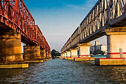
 Anderson Bridge over the Meghna River | |
 | |
| Coordinates: 24°3′N 90°59.3′E / 24.050°N 90.9883°E | |
| Country | |
| Division | Dhaka |
| District | Kishoreganj |
| Headquarters | Bhairab |
| Government | |
| • MP (Member of Parliament) | Nazmul Hassan Papon, (Awami League) |
| • UNO( Upazila Executive Officer) | Israt Shadmin |
| • AC Land | Md. Anisuzzaman |
| • Upazila Chairman | Saidullah Miah,(Awami League) Predecessor:Gias Uddin, (Independent) |
| • Mayor | Iftekhar Hossain Beno,(Awami League) |
| Area | |
• Upazila | 139.32 km2 (53.79 sq mi) |
| • Urban | 15.71 km2 (6.07 sq mi) |
| Elevation | 16 m (52 ft) |
| Population | |
• Upazila | 362,681 |
| • Density | 2,600/km2 (6,700/sq mi) |
| • Urban | 156,293 |
| • Urban density | 9,900/km2 (26,000/sq mi) |
| Time zone | UTC+6 (BST) |
| Postal code | 2350[2] |
| Area code | 09424[3] |
| Website | bhairab |
Bhairab (Bengali: ভৈরব) is a upazila of Kishoreganj District in the Division of Dhaka, Bangladesh. Olukanda was another name of Bhairab. The city centre of this upazila is Bhairab.[4] About 118,992 people live in Bhairab municipality which makes this city the largest in Kishoreganj District and 28th largest city in Bangladesh.
- ^ National Report (PDF). Population and Housing Census 2022. Vol. 1. Dhaka: Bangladesh Bureau of Statistics. November 2023. p. 398. ISBN 978-9844752016.
- ^ "Bangladesh Postal Code". Dhaka: Bangladesh Postal Department under the Department of Posts and Telecommunications of the Ministry of Posts, Telecommunications and Information Technology of the People's Republic of Bangladesh. 20 October 2024.
- ^ "Bangladesh Area Code". China: Chahaoba.com. 18 October 2024.
- ^ Ahmed, Sharif (2012). "Bhairab Upazila". In Islam, Sirajul; Jamal, Ahmed A. (eds.). Banglapedia: National Encyclopedia of Bangladesh (Second ed.). Asiatic Society of Bangladesh.