Back نهر بيج ود ARZ Big Wood River CEB رود بیگ وود Persian Big Wood (rivière) French Биг-Вуд Russian
| Big Wood River | |
|---|---|
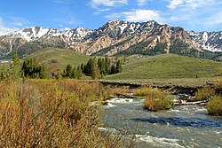
 Big Wood River and Boulder Mountains, July 2009 | |
Location in the United States Location in Idaho | |
| Location | |
| Country | United States |
| State | Idaho |
| Region | Blaine, Lincoln, and Gooding counties |
| Cities | Sun Valley, Ketchum |
| Physical characteristics | |
| Source | Sawtooth Range |
| • location | Galena Summit, Blaine County |
| • coordinates | 43°51′38″N 114°42′48″W / 43.86056°N 114.71333°W[1] |
| • elevation | 9,100 ft (2,770 m)[2] |
| Mouth | Malad River |
• location | Gooding County |
• coordinates | 42°56′42″N 114°47′44″W / 42.94500°N 114.79556°W[1] |
• elevation | 3,460 ft (1,050 m)[2] |
| Length | 137 mi (220 km)[3] |
| Discharge | |
| • location | below Magic Reservoir[4] |
| • average | 464 cu ft/s (13.1 m3/s)[4] |
| • minimum | 0 cu ft/s (0 m3/s) |
| • maximum | 9,800 cu ft/s (280 m3/s) |
| Basin features | |
| Tributaries | |
| • left | North Fork Big Wood River, East Fork Wood River |
| • right | Camas Creek (Big Wood River) |
The Big Wood River is a 137-mile-long (220 km)[3] river in central Idaho, United States, that is a tributary of the Malad River (which in turn is a tributary to the Snake River and Columbia River).
- ^ a b U.S. Geological Survey Geographic Names Information System: Big Wood River
- ^ a b Google Earth elevation for GNIS coordinates
- ^ a b U.S. Geological Survey. National Hydrography Dataset high-resolution flowline data. "The National Map". Archived from the original on 2012-03-29., accessed May 4, 2011
- ^ a b "Water Resource Data, Idaho, 2005"., USGS.

